Le Blanc-Mesnil geodata
Le Blanc-Mesnil (Île-de-France) is a populated place; located in France in Europe/Paris (GMT+2) time zone. With population of 48,077 people, there are 130 cities with bigger population in this country. Compared to other cities in France, 78.3% of cities are located further ↓South; 50% of cities are located further ←West and 82.6% of cities have higher elevation than Le Blanc-Mesnil. Note1
Administrative division(s):
- Level 1: Île-de-France
- Level 2: Seine-Saint-Denis
- Level 3: Arrondissement du Raincy
- Level 4: Le Blanc-Mesnil


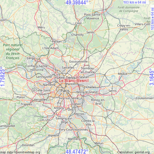
Le Blanc-Mesnil GPS coordinates[2]
48° 56' 19.392" North, 2° 27' 40.968" East
| Map corner | latitude | longitude |
|---|---|---|
| Upper-left | 49.39844°, | 1.75825° |
| Center: | 48.93872°, | 2.46138° |
| Lower-right: | 48.47472°, | 3.1645° |
| Map W x H: | 102.7×102.7 km | = 63.8×63.8mi |
| max Lat: | 51.07786° ⇑21.7% North |
| Le Blanc-Mesnil: | 48.93872° |
| min Lat: | ⇓78.3% South 41.3874° |
| min Long | Le Blanc-Mesnil | max Long |
| -5.08615° | 2.46138° | 9.52242° |
| W 50%⇐ | ⇒50% E |
Elevation
Elevation of Le Blanc-Mesnil is 48 m = 157 ft, and this is 145.7 m = 478 ft below average elevation for this country.
| Max E: |
2333 m = 7654 ft | 82.6% |
| Avg. | 193.7 m = 635 ft | |
| Le Blanc-Mesnil | 48 m = 157 ft | |
Min E: |
-1 m = -3 ft | 17.4% |
See also: Le Blanc-Mesnil elevation on elevation.city.
Geographical zone
Le Blanc-Mesnil is located in North temperate zone (between Tropic of Cancer and the Arctic Circle). Distance of this North polar circle is 1959.7 km =1217.7 mi to North.| Distance of | km | miles | from Le Blanc-Mesnil |
|---|---|---|---|
| North Pole | 4565.6 | 2836.9 | to North |
| Arctic Circle | 1959.7 | 1217.7 | to North |
| Tropic Cancer | 2835.6 | 1762 | to South |
| Equator | 5441.5 | 3381.2 | to South |


Nearby cities:
15 places around Le Blanc-Mesnil: (largest is in red/bold)
• Aulnay-sous-Bois
2.4 km =1.5 mi,  91°
91°
• Bobigny
3.3 km =2.1 mi,  194°
194°
• Bondy
4.6 km =2.9 mi,  153°
153°
• Bonneuil-en-France
4.5 km =2.8 mi,  331°
331°
• Drancy
1.9 km =1.2 mi,  219°
219°
• Dugny
3.6 km =2.2 mi,  297°
297°
• Garges-lès-Gonesse
5.7 km =3.5 mi, 304°
• Gonesse
5.4 km =3.4 mi,  350°
350°
• La Courneuve
4.9 km =3 mi,  255°
255°
• Le Bourget
1.9 km =1.2 mi,  254°
254°
• Les Pavillons-sous-Bois
4.8 km =3 mi,  137°
137°
• Noisy-le-Sec
5.3 km =3.3 mi,  177°
177°
• Sevran
4.9 km =3 mi,  82°
82°
• Stains
5.8 km =3.6 mi,  282°
282°
• Villepinte
5.8 km =3.6 mi,  63°
63°
Sources, notices
• [Note1] Compared only with cities in France existing in our database
• [Src1] Map data: © OpenStreetMap contributors (CC-BY-SA)
• [Src2] Other city data from geonames.org with taken over terms of usage.
• [Src3] Geographical zone / Annual Mean Temperature by Robert A. Rohde @ Wikipedia
