Tournefeuille geodata
Tournefeuille (Occitanie) is a populated place; located in France in Europe/Paris (GMT+2) time zone. With population of 29,124 people, there are 286 cities with bigger population in this country. Compared to other cities in France, 92% of cities are located further ↑North; 65.3% of cities are located further →East and 64% of cities have lower elevation than Tournefeuille. Note1
Administrative division(s):
- Level 1: Occitanie
- Level 2: Haute-Garonne
- Level 3: Arrondissement de Toulouse
- Level 4: Tournefeuille


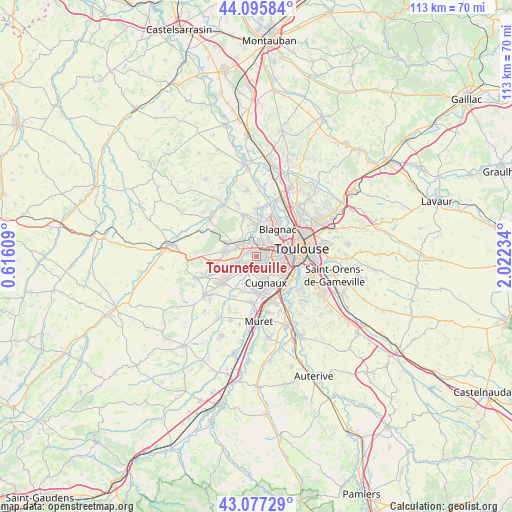
Tournefeuille GPS coordinates[2]
43° 35' 19.392" North, 1° 19' 9.192" East
| Map corner | latitude | longitude |
|---|---|---|
| Upper-left | 44.09584°, | 0.61609° |
| Center: | 43.58872°, | 1.31922° |
| Lower-right: | 43.07729°, | 2.02234° |
| Map W x H: | 113.3×113.3 km | = 70.4×70.4mi |
| max Lat: | 51.07786° ⇑92% North |
| Tournefeuille: | 43.58872° |
| min Lat: | ⇓8% South 41.3874° |
| min Long | Tournefeuille | max Long |
| -5.08615° | 1.31922° | 9.52242° |
| W 34.7%⇐ | ⇒65.3% E |
Elevation
Elevation of Tournefeuille is 189 m = 620 ft, and this is 4.7 m = 15 ft below average elevation for this country.
| Max E: |
2333 m = 7654 ft | 36% |
| Avg. | 193.7 m = 635 ft | |
| Tournefeuille | 189 m = 620 ft | |
Min E: |
-1 m = -3 ft | 64% |
See also: France elevation on elevation.city.
Geographical zone
Tournefeuille is located in North temperate zone (between Tropic of Cancer and the Arctic Circle). Distance of this Northern Tropic circle is 2240.7 km =1392.3 mi to South.| Distance of | km | miles | from Tournefeuille |
|---|---|---|---|
| North Pole | 5160.5 | 3206.6 | to North |
| Arctic Circle | 2554.6 | 1587.4 | to North |
| Tropic Cancer | 2240.7 | 1392.3 | to South |
| Equator | 4846.6 | 3011.5 | to South |


Nearby cities:
15 places around Tournefeuille: (largest is in red/bold)
• Beauzelle
9.8 km =6.1 mi,  27°
27°
• Blagnac
7.8 km =4.8 mi,  50°
50°
• Brax
7.2 km =4.5 mi,  296°
296°
• Colomiers
2.7 km =1.7 mi, 27°
• Cornebarrieu
6.7 km =4.2 mi,  3°
3°
• Cugnaux
6.2 km =3.9 mi,  160°
160°
• Fonsorbes
9.4 km =5.8 mi,  230°
230°
• Frouzins
8.2 km =5.1 mi,  176°
176°
• La Salvetat-Saint-Gilles
4.1 km =2.5 mi,  249°
249°
• Léguevin
7.1 km =4.4 mi,  280°
280°
• Mondonville
9.7 km =6 mi,  344°
344°
• Pibrac
4.5 km =2.8 mi,  322°
322°
• Plaisance-du-Touch
3.1 km =1.9 mi,  214°
214°
• Portet-sur-Garonne
10.1 km =6.3 mi,  135°
135°
• Villeneuve-Tolosane
7.5 km =4.7 mi,  166°
166°
Sources, notices
• [Note1] Compared only with cities in France existing in our database
• [Src1] Map data: © OpenStreetMap contributors (CC-BY-SA)
• [Src2] Other city data from geonames.org with taken over terms of usage.
• [Src3] Geographical zone / Annual Mean Temperature by Robert A. Rohde @ Wikipedia
