Beurey-sur-Saulx geodata
Beurey-sur-Saulx (Grand Est) is a populated place; located in France in Europe/Paris (GMT+2) time zone. With population of 502 people, there are 15200 cities with bigger population in this country. Compared to other cities in France, 74.5% of cities are located further ↓South; 77.9% of cities are located further ←West and 56.1% of cities have lower elevation than Beurey-sur-Saulx. Note1
Administrative division(s):
- Level 1: Grand Est
- Level 2: Meuse
- Level 3: Arrondissement de Bar-le-Duc
- Level 4: Beurey-sur-Saulx


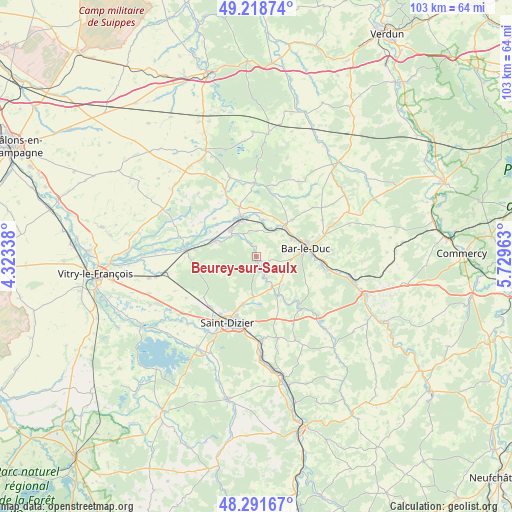
Beurey-sur-Saulx GPS coordinates[2]
48° 45' 26.424" North, 5° 1' 35.4" East
| Map corner | latitude | longitude |
|---|---|---|
| Upper-left | 49.21874°, | 4.32338° |
| Center: | 48.75734°, | 5.0265° |
| Lower-right: | 48.29167°, | 5.72963° |
| Map W x H: | 103.1×103.1 km | = 64.1×64.1mi |
| max Lat: | 51.07786° ⇑25.5% North |
| Beurey-sur-Saulx: | 48.75734° |
| min Lat: | ⇓74.5% South 41.3874° |
| min Long | Beurey-sur-Saul | max Long |
| -5.08615° | 5.0265° | 9.52242° |
| W 77.9%⇐ | ⇒22.1% E |
Elevation
Elevation of Beurey-sur-Saulx is 154 m = 505 ft, and this is 39.7 m = 130 ft below average elevation for this country.
| Max E: |
2333 m = 7654 ft | 43.9% |
| Avg. | 193.7 m = 635 ft | |
| Beurey-sur-Saulx | 154 m = 505 ft | |
Min E: |
-1 m = -3 ft | 56.1% |
See also: France elevation on elevation.city.
Geographical zone
Beurey-sur-Saulx is located in North temperate zone (between Tropic of Cancer and the Arctic Circle). Distance of this North polar circle is 1979.9 km =1230.3 mi to North.| Distance of | km | miles | from Beurey-sur-Saulx |
|---|---|---|---|
| North Pole | 4585.8 | 2849.5 | to North |
| Arctic Circle | 1979.9 | 1230.3 | to North |
| Tropic Cancer | 2815.4 | 1749.4 | to South |
| Equator | 5421.3 | 3368.6 | to South |


Nearby cities:
15 places around Beurey-sur-Saulx: (largest is in red/bold)
• Bar-le-Duc
10 km =6.2 mi,  80°
80°
• Brillon-en-Barrois
7.1 km =4.4 mi,  135°
135°
• Chancenay
10.1 km =6.3 mi,  196°
196°
• Cheminon
9.2 km =5.7 mi,  256°
256°
• Combles-en-Barrois
6.6 km =4.1 mi,  95°
95°
• Contrisson
7.3 km =4.5 mi,  314°
314°
• Fains-Véel
8.3 km =5.2 mi,  69°
69°
• Haironville
8.9 km =5.5 mi,  151°
151°
• Lisle-en-Rigault
4.8 km =3 mi,  160°
160°
• Revigny-sur-Ornain
8.6 km =5.3 mi,  339°
339°
• Robert-Espagne
1.5 km =0.9 mi,  169°
169°
• Savonnières-devant-Bar
11.1 km =6.9 mi,  89°
89°
• Sermaize-les-Bains
9 km =5.6 mi,  290°
290°
• Sommelonne
9.6 km =6 mi,  175°
175°
• Trémont-sur-Saulx
2.7 km =1.7 mi,  111°
111°
Sources, notices
• [Note1] Compared only with cities in France existing in our database
• [Src1] Map data: © OpenStreetMap contributors (CC-BY-SA)
• [Src2] Other city data from geonames.org with taken over terms of usage.
• [Src3] Geographical zone / Annual Mean Temperature by Robert A. Rohde @ Wikipedia
