Trémont-sur-Saulx geodata
Trémont-sur-Saulx (Grand Est) is a populated place; located in France in Europe/Paris (GMT+2) time zone. With population of 621 people, there are 12967 cities with bigger population in this country. Compared to other cities in France, 74.3% of cities are located further ↓South; 78.3% of cities are located further ←West and 59.3% of cities have lower elevation than Trémont-sur-Saulx. Note1
Administrative division(s):
- Level 1: Grand Est
- Level 2: Meuse
- Level 3: Arrondissement de Bar-le-Duc
- Level 4: Trémont-sur-Saulx


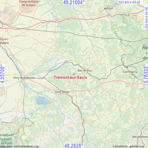
Trémont-sur-Saulx GPS coordinates[2]
48° 44' 54.816" North, 5° 3' 36.72" East
| Map corner | latitude | longitude |
|---|---|---|
| Upper-left | 49.21004°, | 4.35708° |
| Center: | 48.74856°, | 5.0602° |
| Lower-right: | 48.2828°, | 5.76333° |
| Map W x H: | 103.1×103.1 km | = 64.1×64.1mi |
| max Lat: | 51.07786° ⇑25.7% North |
| Trémont-sur-Saulx: | 48.74856° |
| min Lat: | ⇓74.3% South 41.3874° |
| min Long | Trémont-sur-Sa | max Long |
| -5.08615° | 5.0602° | 9.52242° |
| W 78.3%⇐ | ⇒21.7% E |
Elevation
Elevation of Trémont-sur-Saulx is 167 m = 548 ft, and this is 26.7 m = 88 ft below average elevation for this country.
| Max E: |
2333 m = 7654 ft | 40.7% |
| Avg. | 193.7 m = 635 ft | |
| Trémont-sur-Saulx | 167 m = 548 ft | |
Min E: |
-1 m = -3 ft | 59.3% |
See also: France elevation on elevation.city.
Geographical zone
Trémont-sur-Saulx is located in North temperate zone (between Tropic of Cancer and the Arctic Circle). Distance of this North polar circle is 1980.8 km =1230.8 mi to North.| Distance of | km | miles | from Trémont-sur-Saulx |
|---|---|---|---|
| North Pole | 4586.7 | 2850 | to North |
| Arctic Circle | 1980.8 | 1230.8 | to North |
| Tropic Cancer | 2814.4 | 1748.8 | to South |
| Equator | 5420.3 | 3368 | to South |


Nearby cities:
15 places around Trémont-sur-Saulx: (largest is in red/bold)
• Bar-le-Duc
7.9 km =4.9 mi,  70°
70°
• Behonne
10.3 km =6.4 mi,  60°
60°
• Beurey-sur-Saulx
2.7 km =1.7 mi,  291°
291°
• Brillon-en-Barrois
4.8 km =3 mi,  147°
147°
• Chancenay
10.2 km =6.3 mi,  211°
211°
• Combles-en-Barrois
4.1 km =2.5 mi,  85°
85°
• Contrisson
9.8 km =6.1 mi,  308°
308°
• Fains-Véel
6.6 km =4.1 mi,  54°
54°
• Haironville
7.1 km =4.4 mi,  164°
164°
• Lisle-en-Rigault
3.7 km =2.3 mi,  194°
194°
• Longeville-en-Barrois
10.9 km =6.8 mi, 93°
• Revigny-sur-Ornain
10.6 km =6.6 mi,  328°
328°
• Robert-Espagne
2.2 km =1.4 mi,  258°
258°
• Savonnières-devant-Bar
8.7 km =5.4 mi,  83°
83°
• Sommelonne
8.7 km =5.4 mi, 191°
Sources, notices
• [Note1] Compared only with cities in France existing in our database
• [Src1] Map data: © OpenStreetMap contributors (CC-BY-SA)
• [Src2] Other city data from geonames.org with taken over terms of usage.
• [Src3] Geographical zone / Annual Mean Temperature by Robert A. Rohde @ Wikipedia
