Pernois geodata
Pernois (Hauts-de-France) is a populated place; located in France in Europe/Paris (GMT+2) time zone. With population of 654 people, there are 12467 cities with bigger population in this country. Compared to other cities in France, 93.9% of cities are located further ↓South; 54.7% of cities are located further →East and 82.6% of cities have higher elevation than Pernois. Note1
Administrative division(s):
- Level 1: Hauts-de-France
- Level 2: Somme
- Level 3: Amiens
- Level 4: Pernois


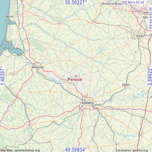
Pernois GPS coordinates[2]
50° 3' 10.548" North, 2° 11' 13.524" East
| Map corner | latitude | longitude |
|---|---|---|
| Upper-left | 50.50227°, | 1.48397° |
| Center: | 50.05293°, | 2.18709° |
| Lower-right: | 49.59934°, | 2.89022° |
| Map W x H: | 100.4×100.4 km | = 62.4×62.4mi |
| max Lat: | 51.07786° ⇑6.1% North |
| Pernois: | 50.05293° |
| min Lat: | ⇓93.9% South 41.3874° |
| min Long | Pernois | max Long |
| -5.08615° | 2.18709° | 9.52242° |
| W 45.3%⇐ | ⇒54.7% E |
Elevation
Elevation of Pernois is 48 m = 157 ft, and this is 145.7 m = 478 ft below average elevation for this country.
| Max E: |
2333 m = 7654 ft | 82.6% |
| Avg. | 193.7 m = 635 ft | |
| Pernois | 48 m = 157 ft | |
Min E: |
-1 m = -3 ft | 17.4% |
See also: France elevation on elevation.city.
Geographical zone
Pernois is located in North temperate zone (between Tropic of Cancer and the Arctic Circle). Distance of this North polar circle is 1835.8 km =1140.7 mi to North.| Distance of | km | miles | from Pernois |
|---|---|---|---|
| North Pole | 4441.7 | 2759.9 | to North |
| Arctic Circle | 1835.8 | 1140.7 | to North |
| Tropic Cancer | 2959.4 | 1838.9 | to South |
| Equator | 5565.4 | 3458.2 | to South |


Nearby cities:
15 places around Pernois: (largest is in red/bold)
• Bernaville
9 km =5.6 mi,  348°
348°
• Berteaucourt-les-Dames
2.2 km =1.4 mi,  252°
252°
• Canaples
2.3 km =1.4 mi,  81°
81°
• Candas
7.9 km =4.9 mi,  40°
40°
• Domart-en-Ponthieu
5 km =3.1 mi,  298°
298°
• Fienvillers
7.9 km =4.9 mi,  22°
22°
• Flesselles
7.7 km =4.8 mi,  136°
136°
• Flixecourt
8.7 km =5.4 mi,  240°
240°
• Naours
6.7 km =4.2 mi,  105°
105°
• Saint-Léger-lès-Domart
3.3 km =2.1 mi,  268°
268°
• Saint-Ouen
5 km =3.1 mi, 250°
• Saint-Vaast-en-Chaussée
9.6 km =6 mi,  174°
174°
• Talmas
10.2 km =6.3 mi,  104°
104°
• Vignacourt
4.6 km =2.9 mi, 170°
• Villers-Bocage
11.1 km =6.9 mi,  123°
123°
Sources, notices
• [Note1] Compared only with cities in France existing in our database
• [Src1] Map data: © OpenStreetMap contributors (CC-BY-SA)
• [Src2] Other city data from geonames.org with taken over terms of usage.
• [Src3] Geographical zone / Annual Mean Temperature by Robert A. Rohde @ Wikipedia
