Beaumetz-lès-Loges geodata
Beaumetz-lès-Loges (Hauts-de-France) is a populated place; located in France in Europe/Paris (GMT+2) time zone. With population of 1,010 people, there are 8771 cities with bigger population in this country. Compared to other cities in France, 95% of cities are located further ↓South; 52.8% of cities are located further ←West and 51.1% of cities have lower elevation than Beaumetz-lès-Loges. Note1
Administrative division(s):
- Level 1: Hauts-de-France
- Level 2: Pas-de-Calais
- Level 3: Arras
- Level 4: Beaumetz-lès-Loges


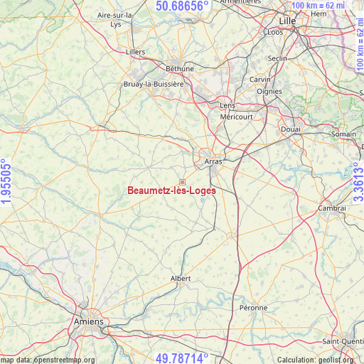
Beaumetz-lès-Loges GPS coordinates[2]
50° 14' 20.292" North, 2° 39' 29.448" East
| Map corner | latitude | longitude |
|---|---|---|
| Upper-left | 50.68656°, | 1.95505° |
| Center: | 50.23897°, | 2.65818° |
| Lower-right: | 49.78714°, | 3.3613° |
| Map W x H: | 100×100 km | = 62.1×62.1mi |
| max Lat: | 51.07786° ⇑5% North |
| Beaumetz-lès-Loges: | 50.23897° |
| min Lat: | ⇓95% South 41.3874° |
| min Long | Beaumetz-lès-L | max Long |
| -5.08615° | 2.65818° | 9.52242° |
| W 52.8%⇐ | ⇒47.2% E |
Elevation
Elevation of Beaumetz-lès-Loges is 136 m = 446 ft, and this is 57.7 m = 189 ft below average elevation for this country.
| Max E: |
2333 m = 7654 ft | 48.9% |
| Avg. | 193.7 m = 635 ft | |
| Beaumetz-lès-Loges | 136 m = 446 ft | |
Min E: |
-1 m = -3 ft | 51.1% |
See also: France elevation on elevation.city.
Geographical zone
Beaumetz-lès-Loges is located in North temperate zone (between Tropic of Cancer and the Arctic Circle). Distance of this North polar circle is 1815.1 km =1127.9 mi to North.| Distance of | km | miles | from Beaumetz-lès-Loges |
|---|---|---|---|
| North Pole | 4421 | 2747.1 | to North |
| Arctic Circle | 1815.1 | 1127.9 | to North |
| Tropic Cancer | 2980.1 | 1851.7 | to South |
| Equator | 5586 | 3471 | to South |


Nearby cities:
15 places around Beaumetz-lès-Loges: (largest is in red/bold)
• Achicourt
8.1 km =5 mi,  60°
60°
• Agnez-lès-Duisans
7.7 km =4.8 mi,  359°
359°
• Agny
7.6 km =4.7 mi,  72°
72°
• Anzin-Saint-Aubin
10.4 km =6.5 mi,  37°
37°
• Avesnes-le-Comte
10.1 km =6.3 mi,  295°
295°
• Beaurains
10.2 km =6.3 mi, 72°
• Dainville
6.7 km =4.2 mi,  45°
45°
• Duisans
7.8 km =4.8 mi,  15°
15°
• Ficheux
5.8 km =3.6 mi,  103°
103°
• Habarcq
8.1 km =5 mi,  335°
335°
• Marœuil
10.1 km =6.3 mi, 19°
• Mercatel
9.8 km =6.1 mi,  92°
92°
• Rivière
2.5 km =1.6 mi,  105°
105°
• Simencourt
2.4 km =1.5 mi,  332°
332°
• Wanquetin
5.1 km =3.2 mi,  322°
322°
Sources, notices
• [Note1] Compared only with cities in France existing in our database
• [Src1] Map data: © OpenStreetMap contributors (CC-BY-SA)
• [Src2] Other city data from geonames.org with taken over terms of usage.
• [Src3] Geographical zone / Annual Mean Temperature by Robert A. Rohde @ Wikipedia
