Bayet geodata
Bayet (Auvergne-Rhône-Alpes) is a populated place; located in France in Europe/Paris (GMT+2) time zone. With population of 651 people, there are 12511 cities with bigger population in this country. Compared to other cities in France, 62.9% of cities are located further ↑North; 61.6% of cities are located further ←West and 75.8% of cities have lower elevation than Bayet. Note1
Administrative division(s):
- Level 1: Auvergne-Rhône-Alpes
- Level 2: Département de l'Allier
- Level 3: Arrondissement de Moulins
- Level 4: Bayet


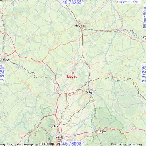
Bayet GPS coordinates[2]
46° 14' 54.492" North, 3° 16' 8.148" East
| Map corner | latitude | longitude |
|---|---|---|
| Upper-left | 46.73255°, | 2.5658° |
| Center: | 46.24847°, | 3.26893° |
| Lower-right: | 45.76008°, | 3.97205° |
| Map W x H: | 108.1×108.1 km | = 67.2×67.2mi |
| max Lat: | 51.07786° ⇑62.9% North |
| Bayet: | 46.24847° |
| min Lat: | ⇓37.1% South 41.3874° |
| min Long | Bayet | max Long |
| -5.08615° | 3.26893° | 9.52242° |
| W 61.6%⇐ | ⇒38.4% E |
Elevation
Elevation of Bayet is 255 m = 837 ft, and this is 61.3 m = 201 ft above average elevation for this country.
| Max E: |
2333 m = 7654 ft | 24.2% |
| Bayet | 255 m 837 ft | |
| Avg. | 193.7 m = 635 ft | |
Min E: |
-1 m = -3 ft | 75.8% |
See also: France elevation on elevation.city.
Geographical zone
Bayet is located in North temperate zone (between Tropic of Cancer and the Arctic Circle). Distance of this North polar circle is 2258.8 km =1403.6 mi to North.| Distance of | km | miles | from Bayet |
|---|---|---|---|
| North Pole | 4864.7 | 3022.8 | to North |
| Arctic Circle | 2258.8 | 1403.6 | to North |
| Tropic Cancer | 2536.4 | 1576 | to South |
| Equator | 5142.3 | 3195.3 | to South |


Nearby cities:
15 places around Bayet: (largest is in red/bold)
• Billy
12.4 km =7.7 mi,  96°
96°
• Bransat
8.7 km =5.4 mi,  339°
339°
• Broût-Vernet
6.8 km =4.2 mi,  177°
177°
• Chantelle
9 km =5.6 mi,  262°
262°
• Charmeil
13.6 km =8.5 mi,  135°
135°
• Contigny
11.9 km =7.4 mi,  13°
13°
• Escurolles
11.7 km =7.3 mi, 181°
• Paray-sous-Briailles
8.7 km =5.4 mi,  57°
57°
• Saint-Germain-des-Fossés
13.5 km =8.4 mi,  110°
110°
• Saint-Pourçain-sur-Sioule
6.7 km =4.2 mi, 13°
• Saint-Rémy-en-Rollat
11.9 km =7.4 mi,  127°
127°
• Saulcet
8.5 km =5.3 mi,  356°
356°
• Varennes-sur-Allier
12.5 km =7.8 mi,  54°
54°
• Vendat
11.4 km =7.1 mi,  145°
145°
• Étroussat
5 km =3.1 mi,  227°
227°
Sources, notices
• [Note1] Compared only with cities in France existing in our database
• [Src1] Map data: © OpenStreetMap contributors (CC-BY-SA)
• [Src2] Other city data from geonames.org with taken over terms of usage.
• [Src3] Geographical zone / Annual Mean Temperature by Robert A. Rohde @ Wikipedia
