Chantelle geodata
Chantelle (Auvergne-Rhône-Alpes) is a populated place; located in France in Europe/Paris (GMT+2) time zone. With population of 1,056 people, there are 8429 cities with bigger population in this country. Compared to other cities in France, 63% of cities are located further ↑North; 60% of cities are located further ←West and 82.1% of cities have lower elevation than Chantelle. Note1
Administrative division(s):
- Level 1: Auvergne-Rhône-Alpes
- Level 2: Département de l'Allier
- Level 3: Arrondissement de Moulins
- Level 4: Chantelle


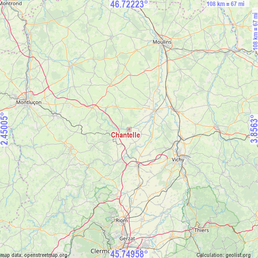
Chantelle GPS coordinates[2]
46° 14' 17.016" North, 3° 9' 11.448" East
| Map corner | latitude | longitude |
|---|---|---|
| Upper-left | 46.72223°, | 2.45005° |
| Center: | 46.23806°, | 3.15318° |
| Lower-right: | 45.74958°, | 3.8563° |
| Map W x H: | 108.1×108.1 km | = 67.2×67.2mi |
| max Lat: | 51.07786° ⇑63% North |
| Chantelle: | 46.23806° |
| min Lat: | ⇓37% South 41.3874° |
| min Long | Chantelle | max Long |
| -5.08615° | 3.15318° | 9.52242° |
| W 60%⇐ | ⇒40% E |
Elevation
Elevation of Chantelle is 311 m = 1020 ft, and this is 117.3 m = 385 ft above average elevation for this country.
| Max E: |
2333 m = 7654 ft | 17.9% |
| Chantelle | 311 m 1020 ft | |
| Avg. | 193.7 m = 635 ft | |
Min E: |
-1 m = -3 ft | 82.1% |
See also: France elevation on elevation.city.
Geographical zone
Chantelle is located in North temperate zone (between Tropic of Cancer and the Arctic Circle). Distance of this North polar circle is 2260 km =1404.3 mi to North.| Distance of | km | miles | from Chantelle |
|---|---|---|---|
| North Pole | 4865.9 | 3023.5 | to North |
| Arctic Circle | 2260 | 1404.3 | to North |
| Tropic Cancer | 2535.3 | 1575.4 | to South |
| Equator | 5141.2 | 3194.6 | to South |


Nearby cities:
15 places around Chantelle: (largest is in red/bold)
• Bayet
9 km =5.6 mi,  82°
82°
• Bellenaves
7 km =4.3 mi,  233°
233°
• Bransat
11 km =6.8 mi,  32°
32°
• Broût-Vernet
10.8 km =6.7 mi,  121°
121°
• Contigny
17.3 km =10.7 mi,  42°
42°
• Escurolles
13.6 km =8.5 mi,  140°
140°
• Gannat
15.8 km =9.8 mi,  167°
167°
• Montmarault
17.6 km =10.9 mi,  300°
300°
• Paray-sous-Briailles
17.3 km =10.7 mi,  70°
70°
• Saint-Bonnet-de-Rochefort
10.3 km =6.4 mi,  186°
186°
• Saint-Pourçain-sur-Sioule
13 km =8.1 mi,  53°
53°
• Saulcet
12.8 km =8 mi, 40°
• Vendat
17.5 km =10.9 mi, 118°
• Ébreuil
14.6 km =9.1 mi,  200°
200°
• Étroussat
5.7 km =3.5 mi,  112°
112°
Sources, notices
• [Note1] Compared only with cities in France existing in our database
• [Src1] Map data: © OpenStreetMap contributors (CC-BY-SA)
• [Src2] Other city data from geonames.org with taken over terms of usage.
• [Src3] Geographical zone / Annual Mean Temperature by Robert A. Rohde @ Wikipedia
