Étroussat geodata
Étroussat (Auvergne-Rhône-Alpes) is a populated place; located in France in Europe/Paris (GMT+2) time zone. With population of 668 people, there are 12251 cities with bigger population in this country. Compared to other cities in France, 63.2% of cities are located further ↑North; 60.9% of cities are located further ←West and 79.9% of cities have lower elevation than Étroussat. Note1
Administrative division(s):
- Level 1: Auvergne-Rhône-Alpes
- Level 2: Département de l'Allier
- Level 3: Arrondissement de Moulins
- Level 4: Étroussat


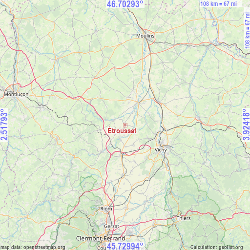
Étroussat GPS coordinates[2]
46° 13' 6.924" North, 3° 13' 15.816" East
| Map corner | latitude | longitude |
|---|---|---|
| Upper-left | 46.70293°, | 2.51793° |
| Center: | 46.21859°, | 3.22106° |
| Lower-right: | 45.72994°, | 3.92418° |
| Map W x H: | 108.2×108.2 km | = 67.2×67.2mi |
| max Lat: | 51.07786° ⇑63.2% North |
| Étroussat: | 46.21859° |
| min Lat: | ⇓36.8% South 41.3874° |
| min Long | Étroussat | max Long |
| -5.08615° | 3.22106° | 9.52242° |
| W 60.9%⇐ | ⇒39.1% E |
Elevation
Elevation of Étroussat is 289 m = 948 ft, and this is 95.3 m = 313 ft above average elevation for this country.
| Max E: |
2333 m = 7654 ft | 20.1% |
| Étroussat | 289 m 948 ft | |
| Avg. | 193.7 m = 635 ft | |
Min E: |
-1 m = -3 ft | 79.9% |
See also: France elevation on elevation.city.
Geographical zone
Étroussat is located in North temperate zone (between Tropic of Cancer and the Arctic Circle). Distance of this North polar circle is 2262.1 km =1405.6 mi to North.| Distance of | km | miles | from Étroussat |
|---|---|---|---|
| North Pole | 4868 | 3024.8 | to North |
| Arctic Circle | 2262.1 | 1405.6 | to North |
| Tropic Cancer | 2533.1 | 1574 | to South |
| Equator | 5139 | 3193.2 | to South |


Nearby cities:
15 places around Étroussat: (largest is in red/bold)
• Bayet
5 km =3.1 mi,  47°
47°
• Bellenaves
11 km =6.8 mi,  259°
259°
• Bransat
11.5 km =7.1 mi,  3°
3°
• Broût-Vernet
5.3 km =3.3 mi,  130°
130°
• Chantelle
5.7 km =3.5 mi,  292°
292°
• Cognat-Lyonne
14.1 km =8.8 mi,  150°
150°
• Escurolles
9 km =5.6 mi,  157°
157°
• Espinasse-Vozelle
13 km =8.1 mi,  142°
142°
• Gannat
13.3 km =8.3 mi,  187°
187°
• Paray-sous-Briailles
13.7 km =8.5 mi, 54°
• Saint-Bonnet-de-Rochefort
10.3 km =6.4 mi,  218°
218°
• Saint-Pourçain-sur-Sioule
11.2 km =7 mi,  27°
27°
• Saint-Rémy-en-Rollat
13.7 km =8.5 mi,  106°
106°
• Saulcet
12.2 km =7.6 mi,  14°
14°
• Vendat
11.9 km =7.4 mi,  120°
120°
Sources, notices
• [Note1] Compared only with cities in France existing in our database
• [Src1] Map data: © OpenStreetMap contributors (CC-BY-SA)
• [Src2] Other city data from geonames.org with taken over terms of usage.
• [Src3] Geographical zone / Annual Mean Temperature by Robert A. Rohde @ Wikipedia
