Vendat geodata
Vendat (Auvergne-Rhône-Alpes) is a populated place; located in France in Europe/Paris (GMT+2) time zone. With population of 2,121 people, there are 4543 cities with bigger population in this country. Compared to other cities in France, 64.1% of cities are located further ↑North; 62.7% of cities are located further ←West and 80.6% of cities have lower elevation than Vendat. Note1
Administrative division(s):
- Level 1: Auvergne-Rhône-Alpes
- Level 2: Département de l'Allier
- Level 3: Arrondissement de Vichy
- Level 4: Vendat


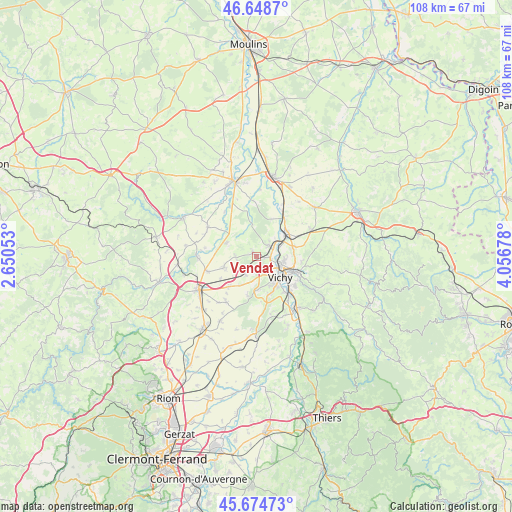
Vendat GPS coordinates[2]
46° 9' 49.932" North, 3° 21' 13.176" East
| Map corner | latitude | longitude |
|---|---|---|
| Upper-left | 46.6487°, | 2.65053° |
| Center: | 46.16387°, | 3.35366° |
| Lower-right: | 45.67473°, | 4.05678° |
| Map W x H: | 108.3×108.3 km | = 67.3×67.3mi |
| max Lat: | 51.07786° ⇑64.1% North |
| Vendat: | 46.16387° |
| min Lat: | ⇓35.9% South 41.3874° |
| min Long | Vendat | max Long |
| -5.08615° | 3.35366° | 9.52242° |
| W 62.7%⇐ | ⇒37.3% E |
Elevation
Elevation of Vendat is 297 m = 974 ft, and this is 103.3 m = 339 ft above average elevation for this country.
| Max E: |
2333 m = 7654 ft | 19.4% |
| Vendat | 297 m 974 ft | |
| Avg. | 193.7 m = 635 ft | |
Min E: |
-1 m = -3 ft | 80.6% |
See also: France elevation on elevation.city.
Geographical zone
Vendat is located in North temperate zone (between Tropic of Cancer and the Arctic Circle). Distance of this North polar circle is 2268.2 km =1409.4 mi to North.| Distance of | km | miles | from Vendat |
|---|---|---|---|
| North Pole | 4874.1 | 3028.6 | to North |
| Arctic Circle | 2268.2 | 1409.4 | to North |
| Tropic Cancer | 2527 | 1570.2 | to South |
| Equator | 5132.9 | 3189.4 | to South |


Nearby cities:
15 places around Vendat: (largest is in red/bold)
• Bellerive-sur-Allier
6.5 km =4 mi,  143°
143°
• Billy
9.9 km =6.2 mi,  35°
35°
• Broût-Vernet
6.7 km =4.2 mi,  293°
293°
• Brugheas
9.7 km =6 mi,  173°
173°
• Charmeil
3 km =1.9 mi,  95°
95°
• Cognat-Lyonne
7 km =4.3 mi,  208°
208°
• Creuzier-le-Neuf
7.7 km =4.8 mi,  74°
74°
• Creuzier-le-Vieux
6.1 km =3.8 mi,  91°
91°
• Cusset
8.6 km =5.3 mi,  112°
112°
• Escurolles
7.2 km =4.5 mi,  251°
251°
• Espinasse-Vozelle
4.7 km =2.9 mi, 208°
• Saint-Germain-des-Fossés
7.8 km =4.8 mi,  52°
52°
• Saint-Rémy-en-Rollat
3.6 km =2.2 mi, 53°
• Serbannes
7.3 km =4.5 mi,  176°
176°
• Vichy
6.9 km =4.3 mi,  126°
126°
Sources, notices
• [Note1] Compared only with cities in France existing in our database
• [Src1] Map data: © OpenStreetMap contributors (CC-BY-SA)
• [Src2] Other city data from geonames.org with taken over terms of usage.
• [Src3] Geographical zone / Annual Mean Temperature by Robert A. Rohde @ Wikipedia
