Vaux-sur-Vienne geodata
Vaux-sur-Vienne (Nouvelle-Aquitaine) is a populated place; located in France in Europe/Paris (GMT+2) time zone. With population of 627 people, there are 12867 cities with bigger population in this country. Compared to other cities in France, 56.1% of cities are located further ↑North; 72.7% of cities are located further →East and 83.4% of cities have higher elevation than Vaux-sur-Vienne. Note1
Administrative division(s):
- Level 1: Nouvelle-Aquitaine
- Level 2: Vienne
- Level 3: Arrondissement de Châtellerault
- Level 4: Vaux-sur-Vienne


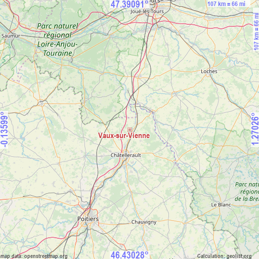
Vaux-sur-Vienne GPS coordinates[2]
46° 54' 45.9" North, 0° 34' 1.704" East
| Map corner | latitude | longitude |
|---|---|---|
| Upper-left | 47.39091°, | -0.13599° |
| Center: | 46.91275°, | 0.56714° |
| Lower-right: | 46.43028°, | 1.27026° |
| Map W x H: | 106.8×106.8 km | = 66.4×66.4mi |
| max Lat: | 51.07786° ⇑56.1% North |
| Vaux-sur-Vienne: | 46.91275° |
| min Lat: | ⇓43.9% South 41.3874° |
| min Long | Vaux-sur-Vienne | max Long |
| -5.08615° | 0.56714° | 9.52242° |
| W 27.3%⇐ | ⇒72.7% E |
Elevation
Elevation of Vaux-sur-Vienne is 46 m = 151 ft, and this is 147.7 m = 485 ft below average elevation for this country.
| Max E: |
2333 m = 7654 ft | 83.4% |
| Avg. | 193.7 m = 635 ft | |
| Vaux-sur-Vienne | 46 m = 151 ft | |
Min E: |
-1 m = -3 ft | 16.6% |
See also: France elevation on elevation.city.
Geographical zone
Vaux-sur-Vienne is located in North temperate zone (between Tropic of Cancer and the Arctic Circle). Distance of this North polar circle is 2185 km =1357.7 mi to North.| Distance of | km | miles | from Vaux-sur-Vienne |
|---|---|---|---|
| North Pole | 4790.9 | 2976.9 | to North |
| Arctic Circle | 2185 | 1357.7 | to North |
| Tropic Cancer | 2610.3 | 1622 | to South |
| Equator | 5216.2 | 3241.2 | to South |


Nearby cities:
15 places around Vaux-sur-Vienne: (largest is in red/bold)
• Abilly
12.8 km =8 mi,  79°
79°
• Antran
6.7 km =4.2 mi,  196°
196°
• Châtellerault
10.8 km =6.7 mi,  188°
188°
• Dangé-Saint-Romain
3.4 km =2.1 mi,  47°
47°
• Descartes
11.7 km =7.3 mi,  59°
59°
• La Celle-Saint-Avant
12.5 km =7.8 mi,  13°
13°
• Les Ormes
7.2 km =4.5 mi,  24°
24°
• Marcilly-sur-Vienne
14.6 km =9.1 mi,  351°
351°
• Marigny-Marmande
9.7 km =6 mi,  322°
322°
• Oyré
6.4 km =4 mi,  133°
133°
• Port-de-Piles
10.3 km =6.4 mi, 14°
• Saint-Gervais-les-Trois-Clochers
12.2 km =7.6 mi,  263°
263°
• Saint-Sauveur
12.4 km =7.7 mi,  159°
159°
• Thuré
12.2 km =7.6 mi,  222°
222°
• Usseau
6 km =3.7 mi,  227°
227°
Sources, notices
• [Note1] Compared only with cities in France existing in our database
• [Src1] Map data: © OpenStreetMap contributors (CC-BY-SA)
• [Src2] Other city data from geonames.org with taken over terms of usage.
• [Src3] Geographical zone / Annual Mean Temperature by Robert A. Rohde @ Wikipedia
