Descartes geodata
Descartes (Centre) is a populated place; located in France in Europe/Paris (GMT+2) time zone. With population of 3,872 people, there are 2537 cities with bigger population in this country. Compared to other cities in France, 55.7% of cities are located further ↑North; 71.4% of cities are located further →East and 83.4% of cities have higher elevation than Descartes. Note1
Administrative division(s):
- Level 1: Centre
- Level 2: Département d'Indre-et-Loire
- Level 3: Arrondissement de Loches
- Level 4: Descartes


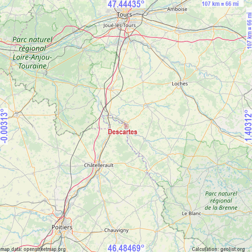
Descartes GPS coordinates[2]
46° 58' 0.012" North, 0° 42' 0" East
| Map corner | latitude | longitude |
|---|---|---|
| Upper-left | 47.44435°, | -0.00313° |
| Center: | 46.96667°, | 0.7° |
| Lower-right: | 46.48469°, | 1.40312° |
| Map W x H: | 106.7×106.7 km | = 66.3×66.3mi |
| max Lat: | 51.07786° ⇑55.7% North |
| Descartes: | 46.96667° |
| min Lat: | ⇓44.3% South 41.3874° |
| min Long | Descartes | max Long |
| -5.08615° | 0.7° | 9.52242° |
| W 28.6%⇐ | ⇒71.4% E |
Elevation
Elevation of Descartes is 46 m = 151 ft, and this is 147.7 m = 485 ft below average elevation for this country.
| Max E: |
2333 m = 7654 ft | 83.4% |
| Avg. | 193.7 m = 635 ft | |
| Descartes | 46 m = 151 ft | |
Min E: |
-1 m = -3 ft | 16.6% |
See also: France elevation on elevation.city.
Geographical zone
Descartes is located in North temperate zone (between Tropic of Cancer and the Arctic Circle). Distance of this North polar circle is 2179 km =1354 mi to North.| Distance of | km | miles | from Descartes |
|---|---|---|---|
| North Pole | 4784.9 | 2973.2 | to North |
| Arctic Circle | 2179 | 1354 | to North |
| Tropic Cancer | 2616.3 | 1625.7 | to South |
| Equator | 5222.2 | 3244.9 | to South |


Nearby cities:
15 places around Descartes: (largest is in red/bold)
• Abilly
4.5 km =2.8 mi,  145°
145°
• Barrou
12.3 km =7.6 mi, 154°
• Cussay
9.3 km =5.8 mi,  46°
46°
• Dangé-Saint-Romain
8.4 km =5.2 mi,  243°
243°
• Draché
11.3 km =7 mi,  330°
330°
• La Celle-Saint-Avant
9.5 km =5.9 mi,  310°
310°
• Le Grand-Pressigny
9.4 km =5.8 mi,  123°
123°
• Les Ormes
7.2 km =4.5 mi,  274°
274°
• Ligueil
12.3 km =7.6 mi, 47°
• Lésigny
14 km =8.7 mi,  159°
159°
• Maillé
13.2 km =8.2 mi,  317°
317°
• Marcilly-sur-Vienne
14.8 km =9.2 mi, 305°
• Oyré
11.8 km =7.3 mi,  207°
207°
• Port-de-Piles
8.6 km =5.3 mi,  297°
297°
• Vaux-sur-Vienne
11.7 km =7.3 mi, 239°
Sources, notices
• [Note1] Compared only with cities in France existing in our database
• [Src1] Map data: © OpenStreetMap contributors (CC-BY-SA)
• [Src2] Other city data from geonames.org with taken over terms of usage.
• [Src3] Geographical zone / Annual Mean Temperature by Robert A. Rohde @ Wikipedia
