Barbizon geodata
Barbizon (Île-de-France) is a populated place; located in France in Europe/Paris (GMT+2) time zone. With population of 1,629 people, there are 5731 cities with bigger population in this country. Compared to other cities in France, 67.1% of cities are located further ↓South; 52.1% of cities are located further ←West and 64.4% of cities have higher elevation than Barbizon. Note1
Administrative division(s):
- Level 1: Île-de-France
- Level 2: Seine-et-Marne
- Level 3: Arrondissement de Fontainebleau
- Level 4: Barbizon


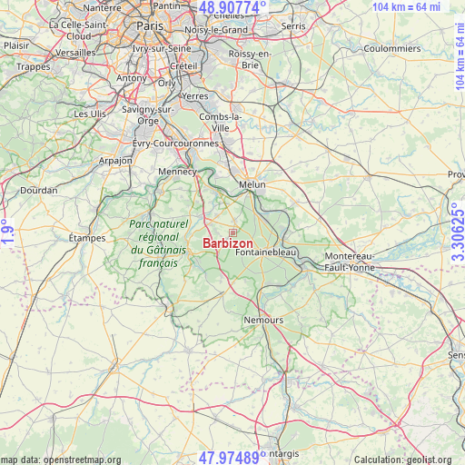
Barbizon GPS coordinates[2]
48° 26' 36.456" North, 2° 36' 11.268" East
| Map corner | latitude | longitude |
|---|---|---|
| Upper-left | 48.90774°, | 1.9° |
| Center: | 48.44346°, | 2.60313° |
| Lower-right: | 47.97489°, | 3.30625° |
| Map W x H: | 103.7×103.7 km | = 64.4×64.4mi |
| max Lat: | 51.07786° ⇑32.9% North |
| Barbizon: | 48.44346° |
| min Lat: | ⇓67.1% South 41.3874° |
| min Long | Barbizon | max Long |
| -5.08615° | 2.60313° | 9.52242° |
| W 52.1%⇐ | ⇒47.9% E |
Elevation
Elevation of Barbizon is 91 m = 299 ft, and this is 102.7 m = 337 ft below average elevation for this country.
| Max E: |
2333 m = 7654 ft | 64.4% |
| Avg. | 193.7 m = 635 ft | |
| Barbizon | 91 m = 299 ft | |
Min E: |
-1 m = -3 ft | 35.6% |
See also: France elevation on elevation.city.
Geographical zone
Barbizon is located in North temperate zone (between Tropic of Cancer and the Arctic Circle). Distance of this North polar circle is 2014.8 km =1251.9 mi to North.| Distance of | km | miles | from Barbizon |
|---|---|---|---|
| North Pole | 4620.7 | 2871.2 | to North |
| Arctic Circle | 2014.8 | 1251.9 | to North |
| Tropic Cancer | 2780.5 | 1727.7 | to South |
| Equator | 5386.4 | 3347 | to South |


Nearby cities:
15 places around Barbizon: (largest is in red/bold)
• Arbonne-la-Forêt
4.2 km =2.6 mi,  219°
219°
• Bois-le-Roi
8.2 km =5.1 mi,  65°
65°
• Chailly-en-Bière
2.6 km =1.6 mi,  7°
7°
• Chartrettes
8.7 km =5.4 mi,  55°
55°
• Cély
5.5 km =3.4 mi,  288°
288°
• Dammarie-les-Lys
8.8 km =5.5 mi,  22°
22°
• Dannemois
9.3 km =5.8 mi,  277°
277°
• Fleury-en-Bière
4 km =2.5 mi,  273°
273°
• Fontainebleau
8.2 km =5.1 mi,  117°
117°
• La Rochette
8.5 km =5.3 mi,  31°
31°
• Perthes
5.2 km =3.2 mi,  317°
317°
• Pringy
8.8 km =5.5 mi,  340°
340°
• Saint-Martin-en-Bière
2.8 km =1.7 mi,  254°
254°
• Saint-Sauveur-sur-École
7.3 km =4.5 mi,  325°
325°
• Soisy-sur-École
8.9 km =5.5 mi, 294°
Sources, notices
• [Note1] Compared only with cities in France existing in our database
• [Src1] Map data: © OpenStreetMap contributors (CC-BY-SA)
• [Src2] Other city data from geonames.org with taken over terms of usage.
• [Src3] Geographical zone / Annual Mean Temperature by Robert A. Rohde @ Wikipedia
