Fontainebleau geodata
Fontainebleau (Île-de-France) is a seat of a third-order administrative division; located in France in Europe/Paris (GMT+2) time zone. With population of 19,717 people, there are 468 cities with bigger population in this country. Compared to other cities in France, 66.5% of cities are located further ↓South; 53.5% of cities are located further ←West and 71% of cities have higher elevation than Fontainebleau. Note1
Administrative division(s):
- Level 1: Île-de-France
- Level 2: Seine-et-Marne
- Level 3: Arrondissement de Fontainebleau
- Level 4: Fontainebleau


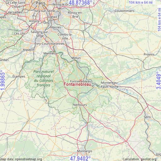
Fontainebleau GPS coordinates[2]
48° 24' 32.688" North, 2° 42' 6.372" East
| Map corner | latitude | longitude |
|---|---|---|
| Upper-left | 48.87368°, | 1.99865° |
| Center: | 48.40908°, | 2.70177° |
| Lower-right: | 47.9402°, | 3.4049° |
| Map W x H: | 103.8×103.8 km | = 64.5×64.5mi |
| max Lat: | 51.07786° ⇑33.5% North |
| Fontainebleau: | 48.40908° |
| min Lat: | ⇓66.5% South 41.3874° |
| min Long | Fontainebleau | max Long |
| -5.08615° | 2.70177° | 9.52242° |
| W 53.5%⇐ | ⇒46.5% E |
Elevation
Elevation of Fontainebleau is 76 m = 249 ft, and this is 117.7 m = 386 ft below average elevation for this country.
| Max E: |
2333 m = 7654 ft | 71% |
| Avg. | 193.7 m = 635 ft | |
| Fontainebleau | 76 m = 249 ft | |
Min E: |
-1 m = -3 ft | 29% |
See also: France elevation on elevation.city.
Geographical zone
Fontainebleau is located in North temperate zone (between Tropic of Cancer and the Arctic Circle). Distance of this North polar circle is 2018.6 km =1254.3 mi to North.| Distance of | km | miles | from Fontainebleau |
|---|---|---|---|
| North Pole | 4624.5 | 2873.5 | to North |
| Arctic Circle | 2018.6 | 1254.3 | to North |
| Tropic Cancer | 2776.7 | 1725.4 | to South |
| Equator | 5382.6 | 3344.6 | to South |


Nearby cities:
15 places around Fontainebleau: (largest is in red/bold)
• Avon
1.6 km =1 mi,  119°
119°
• Barbizon
8.2 km =5.1 mi,  297°
297°
• Bois-le-Roi
7.2 km =4.5 mi,  1°
1°
• Bourron-Marlotte
7.6 km =4.7 mi,  180°
180°
• Champagne-sur-Seine
7.2 km =4.5 mi,  99°
99°
• Chartrettes
8.8 km =5.5 mi,  359°
359°
• Héricy
6.4 km =4 mi,  46°
46°
• Montigny-sur-Loing
8.7 km =5.4 mi,  158°
158°
• Recloses
8.2 km =5.1 mi,  211°
211°
• Saint-Mammès
8.8 km =5.5 mi,  107°
107°
• Samois-sur-Seine
6 km =3.7 mi,  36°
36°
• Samoreau
4.6 km =2.9 mi,  60°
60°
• Thomery
6.4 km =4 mi,  91°
91°
• Veneux-les-Sablons
7.7 km =4.8 mi, 116°
• Vulaines-sur-Seine
5.3 km =3.3 mi, 61°
Sources, notices
• [Note1] Compared only with cities in France existing in our database
• [Src1] Map data: © OpenStreetMap contributors (CC-BY-SA)
• [Src2] Other city data from geonames.org with taken over terms of usage.
• [Src3] Geographical zone / Annual Mean Temperature by Robert A. Rohde @ Wikipedia
