Bain-de-Bretagne geodata
Bain-de-Bretagne (Brittany) is a populated place; located in France in Europe/Paris (GMT+2) time zone. With population of 6,098 people, there are 1620 cities with bigger population in this country. Compared to other cities in France, 56.5% of cities are located further ↓South; 93.4% of cities are located further →East and 59.1% of cities have higher elevation than Bain-de-Bretagne. Note1
Administrative division(s):
- Level 1: Brittany
- Level 2: Département d'Ille-et-Vilaine
- Level 3: Arrondissement de Redon
- Level 4: Bain-de-Bretagne


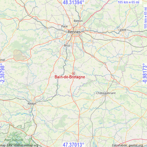
Bain-de-Bretagne GPS coordinates[2]
47° 50' 39.048" North, 1° 41' 5.496" West
| Map corner | latitude | longitude |
|---|---|---|
| Upper-left | 48.31394°, | -2.38798° |
| Center: | 47.84418°, | -1.68486° |
| Lower-right: | 47.37013°, | -0.98173° |
| Map W x H: | 104.9×104.9 km | = 65.2×65.2mi |
| max Lat: | 51.07786° ⇑43.5% North |
| Bain-de-Bretagne: | 47.84418° |
| min Lat: | ⇓56.5% South 41.3874° |
| min Long | Bain-de-Bretagn | max Long |
| -5.08615° | -1.68486° | 9.52242° |
| W 6.6%⇐ | ⇒93.4% E |
Elevation
Elevation of Bain-de-Bretagne is 105 m = 344 ft, and this is 88.7 m = 291 ft below average elevation for this country.
| Max E: |
2333 m = 7654 ft | 59.1% |
| Avg. | 193.7 m = 635 ft | |
| Bain-de-Bretagne | 105 m = 344 ft | |
Min E: |
-1 m = -3 ft | 40.9% |
See also: France elevation on elevation.city.
Geographical zone
Bain-de-Bretagne is located in North temperate zone (between Tropic of Cancer and the Arctic Circle). Distance of this North polar circle is 2081.4 km =1293.3 mi to North.| Distance of | km | miles | from Bain-de-Bretagne |
|---|---|---|---|
| North Pole | 4687.3 | 2912.6 | to North |
| Arctic Circle | 2081.4 | 1293.3 | to North |
| Tropic Cancer | 2713.9 | 1686.3 | to South |
| Equator | 5319.8 | 3305.6 | to South |


Nearby cities:
15 places around Bain-de-Bretagne: (largest is in red/bold)
• Bourg-des-Comptes
10.5 km =6.5 mi,  334°
334°
• Crevin
10 km =6.2 mi,  7°
7°
• Ercé-en-Lamée
9.5 km =5.9 mi,  99°
99°
• La Dominelais
9.1 km =5.7 mi,  181°
181°
• La Noë-Blanche
6.1 km =3.8 mi,  223°
223°
• Le Petit-Fougeray
10.9 km =6.8 mi,  31°
31°
• Le Sel-de-Bretagne
8 km =5 mi,  39°
39°
• Messac
9.7 km =6 mi,  256°
256°
• Pancé
4.6 km =2.9 mi,  24°
24°
• Pléchâtel
7.4 km =4.6 mi,  319°
319°
• Poligné
4.8 km =3 mi,  359°
359°
• Saint-Malo-de-Phily
8.5 km =5.3 mi,  295°
295°
• Saint-Senoux
10.3 km =6.4 mi,  311°
311°
• Saulnières
10.8 km =6.7 mi, 43°
• Tresbœuf
11 km =6.8 mi,  66°
66°
Sources, notices
• [Note1] Compared only with cities in France existing in our database
• [Src1] Map data: © OpenStreetMap contributors (CC-BY-SA)
• [Src2] Other city data from geonames.org with taken over terms of usage.
• [Src3] Geographical zone / Annual Mean Temperature by Robert A. Rohde @ Wikipedia
