Messac geodata
Messac (Brittany) is a populated place; located in France in Europe/Paris (GMT+2) time zone. With population of 2,530 people, there are 3856 cities with bigger population in this country. Compared to other cities in France, 56.2% of cities are located further ↓South; 94.1% of cities are located further →East and 96.7% of cities have higher elevation than Messac. Note1
Administrative division(s):
- Level 1: Brittany
- Level 2: Département d'Ille-et-Vilaine
- Level 3: Arrondissement de Redon
- Level 4: Guipry-Messac


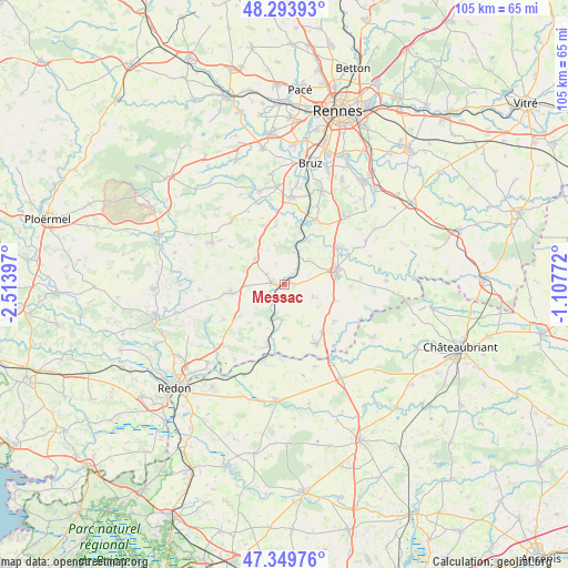
Messac GPS coordinates[2]
47° 49' 26.364" North, 1° 48' 39.06" West
| Map corner | latitude | longitude |
|---|---|---|
| Upper-left | 48.29393°, | -2.51397° |
| Center: | 47.82399°, | -1.81085° |
| Lower-right: | 47.34976°, | -1.10772° |
| Map W x H: | 105×105 km | = 65.2×65.2mi |
| max Lat: | 51.07786° ⇑43.8% North |
| Messac: | 47.82399° |
| min Lat: | ⇓56.2% South 41.3874° |
| min Long | Messac | max Long |
| -5.08615° | -1.81085° | 9.52242° |
| W 5.9%⇐ | ⇒94.1% E |
Elevation
Elevation of Messac is 12 m = 39 ft, and this is 181.7 m = 596 ft below average elevation for this country.
| Max E: |
2333 m = 7654 ft | 96.7% |
| Avg. | 193.7 m = 635 ft | |
| Messac | 12 m = 39 ft | |
Min E: |
-1 m = -3 ft | 3.3% |
See also: France elevation on elevation.city.
Geographical zone
Messac is located in North temperate zone (between Tropic of Cancer and the Arctic Circle). Distance of this North polar circle is 2083.6 km =1294.7 mi to North.| Distance of | km | miles | from Messac |
|---|---|---|---|
| North Pole | 4689.5 | 2913.9 | to North |
| Arctic Circle | 2083.6 | 1294.7 | to North |
| Tropic Cancer | 2711.6 | 1684.9 | to South |
| Equator | 5317.5 | 3304.1 | to South |


Nearby cities:
15 places around Messac: (largest is in red/bold)
• Bain-de-Bretagne
9.7 km =6 mi,  76°
76°
• Grand-Fougeray
12.6 km =7.8 mi,  152°
152°
• Guignen
11.3 km =7 mi,  340°
340°
• Guipry
2.4 km =1.5 mi,  276°
276°
• La Dominelais
11.4 km =7.1 mi,  126°
126°
• La Noë-Blanche
5.6 km =3.5 mi,  113°
113°
• Langon
11.9 km =7.4 mi,  194°
194°
• Lieuron
10.3 km =6.4 mi,  287°
287°
• Lohéac
7.2 km =4.5 mi,  311°
311°
• Pipriac
10.2 km =6.3 mi,  260°
260°
• Pléchâtel
9.2 km =5.7 mi,  30°
30°
• Poligné
11.7 km =7.3 mi,  53°
53°
• Saint-Malo-de-Phily
6.1 km =3.8 mi,  16°
16°
• Saint-Senoux
9.2 km =5.7 mi,  10°
10°
• Sainte-Anne-sur-Vilaine
10.5 km =6.5 mi, 185°
Sources, notices
• [Note1] Compared only with cities in France existing in our database
• [Src1] Map data: © OpenStreetMap contributors (CC-BY-SA)
• [Src2] Other city data from geonames.org with taken over terms of usage.
• [Src3] Geographical zone / Annual Mean Temperature by Robert A. Rohde @ Wikipedia
