Aubière geodata
Aubière (Auvergne-Rhône-Alpes) is a populated place; located in France in Europe/Paris (GMT+2) time zone. With population of 11,054 people, there are 870 cities with bigger population in this country. Compared to other cities in France, 70.1% of cities are located further ↑North; 59.4% of cities are located further ←West and 86.4% of cities have lower elevation than Aubière. Note1
Administrative division(s):
- Level 1: Auvergne-Rhône-Alpes
- Level 2: Département du Puy-de-Dôme
- Level 3: Arrondissement de Clermont-Ferrand
- Level 4: Aubière


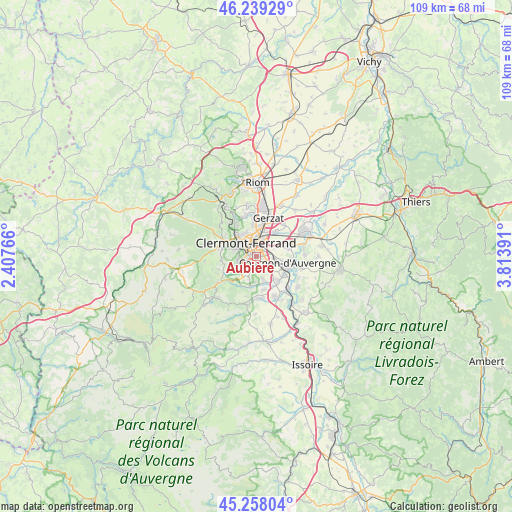
Aubière GPS coordinates[2]
45° 45' 2.952" North, 3° 6' 38.808" East
| Map corner | latitude | longitude |
|---|---|---|
| Upper-left | 46.23929°, | 2.40766° |
| Center: | 45.75082°, | 3.11078° |
| Lower-right: | 45.25804°, | 3.81391° |
| Map W x H: | 109.1×109.1 km | = 67.8×67.8mi |
| max Lat: | 51.07786° ⇑70.1% North |
| Aubière: | 45.75082° |
| min Lat: | ⇓29.9% South 41.3874° |
| min Long | Aubière | max Long |
| -5.08615° | 3.11078° | 9.52242° |
| W 59.4%⇐ | ⇒40.6% E |
Elevation
Elevation of Aubière is 366 m = 1201 ft, and this is 172.3 m = 565 ft above average elevation for this country.
| Max E: |
2333 m = 7654 ft | 13.6% |
| Aubière | 366 m 1201 ft | |
| Avg. | 193.7 m = 635 ft | |
Min E: |
-1 m = -3 ft | 86.4% |
See also: France elevation on elevation.city.
Geographical zone
Aubière is located in North temperate zone (between Tropic of Cancer and the Arctic Circle). Distance of this North polar circle is 2314.2 km =1438 mi to North.| Distance of | km | miles | from Aubière |
|---|---|---|---|
| North Pole | 4920 | 3057.1 | to North |
| Arctic Circle | 2314.2 | 1438 | to North |
| Tropic Cancer | 2481.1 | 1541.7 | to South |
| Equator | 5087 | 3160.9 | to South |


Nearby cities:
15 places around Aubière: (largest is in red/bold)
• Aulnat
7 km =4.3 mi,  39°
39°
• Beaumont
2.2 km =1.4 mi,  272°
272°
• Ceyrat
4.2 km =2.6 mi,  241°
241°
• Chamalières
4.2 km =2.6 mi,  306°
306°
• Chanonat
6.6 km =4.1 mi,  191°
191°
• Clermont-Ferrand
3.7 km =2.3 mi,  329°
329°
• Cournon-d’Auvergne
6.7 km =4.2 mi,  99°
99°
• Durtol
6.8 km =4.2 mi,  317°
317°
• La Roche-Blanche
5.7 km =3.5 mi,  167°
167°
• Le Cendre
6.7 km =4.2 mi,  118°
118°
• Le Crest
7.2 km =4.5 mi, 169°
• Orcet
6.9 km =4.3 mi,  139°
139°
• Pérignat-lès-Sarliève
2.7 km =1.7 mi,  125°
125°
• Romagnat
2.5 km =1.6 mi,  198°
198°
• Royat
5 km =3.1 mi,  288°
288°
Sources, notices
• [Note1] Compared only with cities in France existing in our database
• [Src1] Map data: © OpenStreetMap contributors (CC-BY-SA)
• [Src2] Other city data from geonames.org with taken over terms of usage.
• [Src3] Geographical zone / Annual Mean Temperature by Robert A. Rohde @ Wikipedia
