Clermont-Ferrand geodata
Clermont-Ferrand (Auvergne-Rhône-Alpes) is a seat of a second-order administrative division; located in France in Europe/Paris (GMT+2) time zone. With population of 138,681 people, there are 27 cities with bigger population in this country. Compared to other cities in France, 69.5% of cities are located further ↑North; 59.1% of cities are located further ←West and 88.9% of cities have lower elevation than Clermont-Ferrand. Note1
Administrative division(s):
- Level 1: Auvergne-Rhône-Alpes
- Level 2: Département du Puy-de-Dôme
- Level 3: Arrondissement de Clermont-Ferrand
- Level 4: Clermont-Ferrand


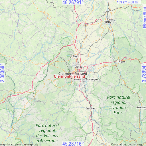
Clermont-Ferrand GPS coordinates[2]
45° 46' 46.884" North, 3° 5' 12.552" East
| Map corner | latitude | longitude |
|---|---|---|
| Upper-left | 46.26791°, | 2.38369° |
| Center: | 45.77969°, | 3.08682° |
| Lower-right: | 45.28716°, | 3.78994° |
| Map W x H: | 109×109 km | = 67.7×67.7mi |
| max Lat: | 51.07786° ⇑69.5% North |
| Clermont-Ferrand: | 45.77969° |
| min Lat: | ⇓30.5% South 41.3874° |
| min Long | Clermont-Ferran | max Long |
| -5.08615° | 3.08682° | 9.52242° |
| W 59.1%⇐ | ⇒40.9% E |
Elevation
Elevation of Clermont-Ferrand is 406 m = 1332 ft, and this is 212.3 m = 697 ft above average elevation for this country.
| Max E: |
2333 m = 7654 ft | 11.1% |
| Clermont-Ferrand | 406 m 1332 ft | |
| Avg. | 193.7 m = 635 ft | |
Min E: |
-1 m = -3 ft | 88.9% |
See also: Clermont-Ferrand elevation on elevation.city.
Geographical zone
Clermont-Ferrand is located in North temperate zone (between Tropic of Cancer and the Arctic Circle). Distance of this North polar circle is 2310.9 km =1435.9 mi to North.| Distance of | km | miles | from Clermont-Ferrand |
|---|---|---|---|
| North Pole | 4916.8 | 3055.2 | to North |
| Arctic Circle | 2310.9 | 1435.9 | to North |
| Tropic Cancer | 2484.3 | 1543.7 | to South |
| Equator | 5090.2 | 3162.9 | to South |


Nearby cities:
15 places around Clermont-Ferrand: (largest is in red/bold)
• Aubière
3.7 km =2.3 mi,  149°
149°
• Aulnat
6.6 km =4.1 mi,  70°
70°
• Beaumont
3.1 km =1.9 mi,  185°
185°
• Blanzat
5.6 km =3.5 mi,  352°
352°
• Ceyrat
5.5 km =3.4 mi,  199°
199°
• Chamalières
1.7 km =1.1 mi,  246°
246°
• Cébazat
5.8 km =3.6 mi,  10°
10°
• Durtol
3.3 km =2.1 mi,  303°
303°
• Gerzat
6.8 km =4.2 mi,  41°
41°
• Nohanent
4 km =2.5 mi,  322°
322°
• Orcines
5.8 km =3.6 mi,  273°
273°
• Pérignat-lès-Sarliève
6.3 km =3.9 mi,  139°
139°
• Romagnat
5.7 km =3.5 mi,  169°
169°
• Royat
3.3 km =2.1 mi,  240°
240°
• Sayat
5.8 km =3.6 mi,  332°
332°
Sources, notices
• [Note1] Compared only with cities in France existing in our database
• [Src1] Map data: © OpenStreetMap contributors (CC-BY-SA)
• [Src2] Other city data from geonames.org with taken over terms of usage.
• [Src3] Geographical zone / Annual Mean Temperature by Robert A. Rohde @ Wikipedia
