Lantéfontaine geodata
Lantéfontaine (Grand Est) is a populated place; located in France in Europe/Paris (GMT+2) time zone. With population of 715 people, there are 11591 cities with bigger population in this country. Compared to other cities in France, 85.1% of cities are located further ↓South; 86% of cities are located further ←West and 71.7% of cities have lower elevation than Lantéfontaine. Note1
Administrative division(s):
- Level 1: Grand Est
- Level 2: Meurthe-et-Moselle
- Level 3: Arrondissement de Briey
- Level 4: Lantéfontaine


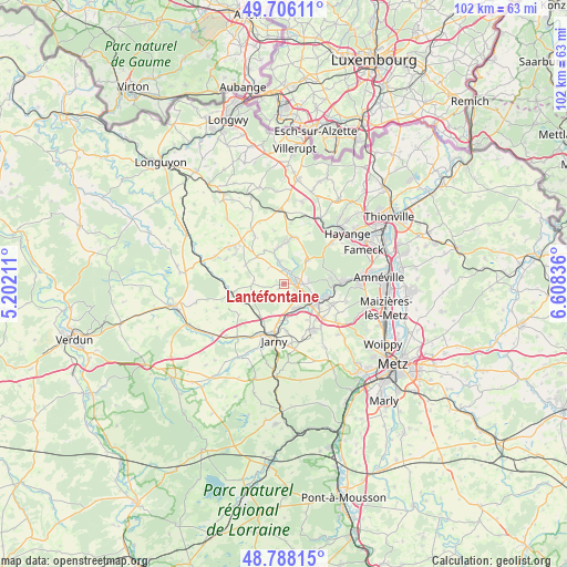
Lantéfontaine GPS coordinates[2]
49° 14' 57.336" North, 5° 54' 18.864" East
| Map corner | latitude | longitude |
|---|---|---|
| Upper-left | 49.70611°, | 5.20211° |
| Center: | 49.24926°, | 5.90524° |
| Lower-right: | 48.78815°, | 6.60836° |
| Map W x H: | 102.1×102.1 km | = 63.4×63.4mi |
| max Lat: | 51.07786° ⇑14.9% North |
| Lantéfontaine: | 49.24926° |
| min Lat: | ⇓85.1% South 41.3874° |
| min Long | Lantéfontaine | max Long |
| -5.08615° | 5.90524° | 9.52242° |
| W 86%⇐ | ⇒14% E |
Elevation
Elevation of Lantéfontaine is 228 m = 748 ft, and this is 34.3 m = 113 ft above average elevation for this country.
| Max E: |
2333 m = 7654 ft | 28.3% |
| Lantéfontaine | 228 m 748 ft | |
| Avg. | 193.7 m = 635 ft | |
Min E: |
-1 m = -3 ft | 71.7% |
See also: France elevation on elevation.city.
Geographical zone
Lantéfontaine is located in North temperate zone (between Tropic of Cancer and the Arctic Circle). Distance of this North polar circle is 1925.2 km =1196.3 mi to North.| Distance of | km | miles | from Lantéfontaine |
|---|---|---|---|
| North Pole | 4531.1 | 2815.5 | to North |
| Arctic Circle | 1925.2 | 1196.3 | to North |
| Tropic Cancer | 2870.1 | 1783.4 | to South |
| Equator | 5476 | 3402.6 | to South |


Nearby cities:
15 places around Lantéfontaine: (largest is in red/bold)
• Auboué
6.6 km =4.1 mi,  128°
128°
• Avril
6.1 km =3.8 mi,  45°
45°
• Briey
2.5 km =1.6 mi,  90°
90°
• Giraumont
8.8 km =5.5 mi,  175°
175°
• Hatrize
6.3 km =3.9 mi, 177°
• Homécourt
7.1 km =4.4 mi,  116°
116°
• Jœuf
8.3 km =5.2 mi,  102°
102°
• Labry
8.7 km =5.4 mi,  191°
191°
• Mance
2.3 km =1.4 mi,  20°
20°
• Mancieulles
3.7 km =2.3 mi,  349°
349°
• Moineville
5.7 km =3.5 mi,  150°
150°
• Moutiers
4.7 km =2.9 mi,  112°
112°
• Trieux
8.6 km =5.3 mi,  12°
12°
• Tucquegnieux
6.8 km =4.2 mi, 353°
• Valleroy
5 km =3.1 mi, 152°
Sources, notices
• [Note1] Compared only with cities in France existing in our database
• [Src1] Map data: © OpenStreetMap contributors (CC-BY-SA)
• [Src2] Other city data from geonames.org with taken over terms of usage.
• [Src3] Geographical zone / Annual Mean Temperature by Robert A. Rohde @ Wikipedia
