Athis-Mons geodata
Athis-Mons (Île-de-France) is a populated place; located in France in Europe/Paris (GMT+2) time zone. With population of 31,225 people, there are 255 cities with bigger population in this country. Compared to other cities in France, 73.4% of cities are located further ↓South; 51.2% of cities are located further →East and 88.6% of cities have higher elevation than Athis-Mons. Note1
Administrative division(s):
- Level 1: Île-de-France
- Level 2: Département de l'Essonne
- Level 3: Arrondissement de Palaiseau
- Level 4: Athis-Mons


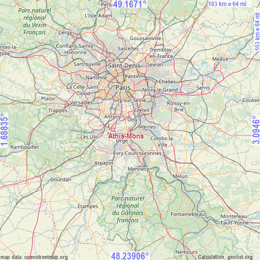
Athis-Mons GPS coordinates[2]
48° 42' 18.792" North, 2° 23' 29.292" East
| Map corner | latitude | longitude |
|---|---|---|
| Upper-left | 49.1671°, | 1.68835° |
| Center: | 48.70522°, | 2.39147° |
| Lower-right: | 48.23906°, | 3.0946° |
| Map W x H: | 103.2×103.2 km | = 64.1×64.1mi |
| max Lat: | 51.07786° ⇑26.6% North |
| Athis-Mons: | 48.70522° |
| min Lat: | ⇓73.4% South 41.3874° |
| min Long | Athis-Mons | max Long |
| -5.08615° | 2.39147° | 9.52242° |
| W 48.8%⇐ | ⇒51.2% E |
Elevation
Elevation of Athis-Mons is 33 m = 108 ft, and this is 160.7 m = 527 ft below average elevation for this country.
| Max E: |
2333 m = 7654 ft | 88.6% |
| Avg. | 193.7 m = 635 ft | |
| Athis-Mons | 33 m = 108 ft | |
Min E: |
-1 m = -3 ft | 11.4% |
See also: France elevation on elevation.city.
Geographical zone
Athis-Mons is located in North temperate zone (between Tropic of Cancer and the Arctic Circle). Distance of this North polar circle is 1985.7 km =1233.9 mi to North.| Distance of | km | miles | from Athis-Mons |
|---|---|---|---|
| North Pole | 4591.5 | 2853 | to North |
| Arctic Circle | 1985.7 | 1233.9 | to North |
| Tropic Cancer | 2809.6 | 1745.8 | to South |
| Equator | 5415.5 | 3365 | to South |


Nearby cities:
15 places around Athis-Mons: (largest is in red/bold)
• Ablon-sur-Seine
3.6 km =2.2 mi,  46°
46°
• Crosne
5.1 km =3.2 mi,  72°
72°
• Draveil
2.8 km =1.7 mi,  143°
143°
• Juvisy-sur-Orge
2.5 km =1.6 mi,  193°
193°
• Montgeron
4.3 km =2.7 mi,  89°
89°
• Morangis
3.8 km =2.4 mi,  267°
267°
• Morsang-sur-Orge
5.6 km =3.5 mi,  210°
210°
• Orly
4.7 km =2.9 mi,  0°
0°
• Paray-Vieille-Poste
2.3 km =1.4 mi,  294°
294°
• Rungis
5.4 km =3.4 mi,  327°
327°
• Savigny-sur-Orge
4.5 km =2.8 mi,  225°
225°
• Vigneux-sur-Seine
1.6 km =1 mi,  98°
98°
• Villeneuve-Saint-Georges
5.2 km =3.2 mi, 54°
• Villeneuve-le-Roi
3.6 km =2.2 mi,  11°
11°
• Viry-Châtillon
3.7 km =2.3 mi,  178°
178°
Sources, notices
• [Note1] Compared only with cities in France existing in our database
• [Src1] Map data: © OpenStreetMap contributors (CC-BY-SA)
• [Src2] Other city data from geonames.org with taken over terms of usage.
• [Src3] Geographical zone / Annual Mean Temperature by Robert A. Rohde @ Wikipedia
