Draveil geodata
Draveil (Île-de-France) is a populated place; located in France in Europe/Paris (GMT+2) time zone. With population of 29,316 people, there are 282 cities with bigger population in this country. Compared to other cities in France, 72.9% of cities are located further ↓South; 50.9% of cities are located further →East and 79.4% of cities have higher elevation than Draveil. Note1
Administrative division(s):
- Level 1: Île-de-France
- Level 2: Département de l'Essonne
- Level 3: Arrondissement d'Évry
- Level 4: Draveil


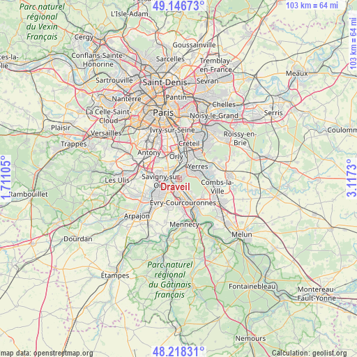
Draveil GPS coordinates[2]
48° 41' 4.776" North, 2° 24' 51.048" East
| Map corner | latitude | longitude |
|---|---|---|
| Upper-left | 49.14673°, | 1.71105° |
| Center: | 48.68466°, | 2.41418° |
| Lower-right: | 48.21831°, | 3.1173° |
| Map W x H: | 103.2×103.2 km | = 64.1×64.1mi |
| max Lat: | 51.07786° ⇑27.1% North |
| Draveil: | 48.68466° |
| min Lat: | ⇓72.9% South 41.3874° |
| min Long | Draveil | max Long |
| -5.08615° | 2.41418° | 9.52242° |
| W 49.1%⇐ | ⇒50.9% E |
Elevation
Elevation of Draveil is 56 m = 184 ft, and this is 137.7 m = 452 ft below average elevation for this country.
| Max E: |
2333 m = 7654 ft | 79.4% |
| Avg. | 193.7 m = 635 ft | |
| Draveil | 56 m = 184 ft | |
Min E: |
-1 m = -3 ft | 20.6% |
See also: France elevation on elevation.city.
Geographical zone
Draveil is located in North temperate zone (between Tropic of Cancer and the Arctic Circle). Distance of this North polar circle is 1987.9 km =1235.2 mi to North.| Distance of | km | miles | from Draveil |
|---|---|---|---|
| North Pole | 4593.8 | 2854.5 | to North |
| Arctic Circle | 1987.9 | 1235.2 | to North |
| Tropic Cancer | 2807.3 | 1744.4 | to South |
| Equator | 5413.2 | 3363.6 | to South |


Nearby cities:
15 places around Draveil: (largest is in red/bold)
• Ablon-sur-Seine
4.8 km =3 mi,  11°
11°
• Athis-Mons
2.8 km =1.7 mi,  323°
323°
• Brunoy
5.8 km =3.6 mi,  79°
79°
• Crosne
5 km =3.1 mi,  39°
39°
• Grigny
3.7 km =2.3 mi,  204°
204°
• Juvisy-sur-Orge
2.3 km =1.4 mi,  266°
266°
• Montgeron
3.5 km =2.2 mi,  49°
49°
• Morsang-sur-Orge
5.1 km =3.2 mi,  240°
240°
• Paray-Vieille-Poste
5 km =3.1 mi,  310°
310°
• Ris-Orangis
3.7 km =2.3 mi,  180°
180°
• Savigny-sur-Orge
4.9 km =3 mi,  259°
259°
• Soisy-sur-Seine
4.9 km =3 mi,  145°
145°
• Vigneux-sur-Seine
2 km =1.2 mi,  358°
358°
• Villeneuve-Saint-Georges
5.9 km =3.7 mi,  25°
25°
• Viry-Châtillon
2.1 km =1.3 mi,  227°
227°
Sources, notices
• [Note1] Compared only with cities in France existing in our database
• [Src1] Map data: © OpenStreetMap contributors (CC-BY-SA)
• [Src2] Other city data from geonames.org with taken over terms of usage.
• [Src3] Geographical zone / Annual Mean Temperature by Robert A. Rohde @ Wikipedia
