Ablon-sur-Seine geodata
Ablon-sur-Seine (Île-de-France) is a populated place; located in France in Europe/Paris (GMT+2) time zone. With population of 5,174 people, there are 1905 cities with bigger population in this country. Compared to other cities in France, 73.8% of cities are located further ↓South; 50.6% of cities are located further →East and 88.3% of cities have higher elevation than Ablon-sur-Seine. Note1
Administrative division(s):
- Level 1: Île-de-France
- Level 2: Val-de-Marne
- Level 3: Arrondissement de L'Haÿ-les-Roses
- Level 4: Ablon-sur-Seine


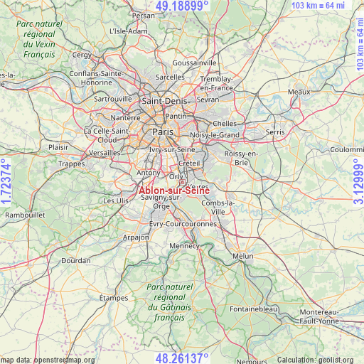
Ablon-sur-Seine GPS coordinates[2]
48° 43' 38.352" North, 2° 25' 36.696" East
| Map corner | latitude | longitude |
|---|---|---|
| Upper-left | 49.18899°, | 1.72374° |
| Center: | 48.72732°, | 2.42686° |
| Lower-right: | 48.26137°, | 3.12999° |
| Map W x H: | 103.1×103.1 km | = 64.1×64.1mi |
| max Lat: | 51.07786° ⇑26.2% North |
| Ablon-sur-Seine: | 48.72732° |
| min Lat: | ⇓73.8% South 41.3874° |
| min Long | Ablon-sur-Seine | max Long |
| -5.08615° | 2.42686° | 9.52242° |
| W 49.4%⇐ | ⇒50.6% E |
Elevation
Elevation of Ablon-sur-Seine is 34 m = 112 ft, and this is 159.7 m = 524 ft below average elevation for this country.
| Max E: |
2333 m = 7654 ft | 88.3% |
| Avg. | 193.7 m = 635 ft | |
| Ablon-sur-Seine | 34 m = 112 ft | |
Min E: |
-1 m = -3 ft | 11.7% |
See also: France elevation on elevation.city.
Geographical zone
Ablon-sur-Seine is located in North temperate zone (between Tropic of Cancer and the Arctic Circle). Distance of this North polar circle is 1983.2 km =1232.3 mi to North.| Distance of | km | miles | from Ablon-sur-Seine |
|---|---|---|---|
| North Pole | 4589.1 | 2851.5 | to North |
| Arctic Circle | 1983.2 | 1232.3 | to North |
| Tropic Cancer | 2812.1 | 1747.4 | to South |
| Equator | 5418 | 3366.6 | to South |


Nearby cities:
15 places around Ablon-sur-Seine: (largest is in red/bold)
• Athis-Mons
3.6 km =2.2 mi,  226°
226°
• Choisy-le-Roi
4.6 km =2.9 mi,  352°
352°
• Crosne
2.4 km =1.5 mi,  112°
112°
• Draveil
4.8 km =3 mi,  191°
191°
• Juvisy-sur-Orge
5.8 km =3.6 mi,  213°
213°
• Limeil-Brévannes
4.8 km =3 mi,  66°
66°
• Montgeron
3 km =1.9 mi,  144°
144°
• Orly
3.4 km =2.1 mi,  312°
312°
• Paray-Vieille-Poste
4.9 km =3 mi,  252°
252°
• Thiais
4.8 km =3 mi,  331°
331°
• Valenton
3.4 km =2.1 mi,  54°
54°
• Vigneux-sur-Seine
2.9 km =1.8 mi,  199°
199°
• Villeneuve-Saint-Georges
1.7 km =1.1 mi, 71°
• Villeneuve-le-Roi
2.2 km =1.4 mi,  298°
298°
• Yerres
5 km =3.1 mi,  102°
102°
Sources, notices
• [Note1] Compared only with cities in France existing in our database
• [Src1] Map data: © OpenStreetMap contributors (CC-BY-SA)
• [Src2] Other city data from geonames.org with taken over terms of usage.
• [Src3] Geographical zone / Annual Mean Temperature by Robert A. Rohde @ Wikipedia
