Villeneuve-Saint-Georges geodata
Villeneuve-Saint-Georges (Île-de-France) is a populated place; located in France in Europe/Paris (GMT+2) time zone. With population of 30,881 people, there are 261 cities with bigger population in this country. Compared to other cities in France, 73.9% of cities are located further ↓South; 50.2% of cities are located further →East and 87.8% of cities have higher elevation than Villeneuve-Saint-Georges. Note1
Administrative division(s):
- Level 1: Île-de-France
- Level 2: Val-de-Marne
- Level 3: Arrondissement de L'Haÿ-les-Roses
- Level 4: Villeneuve-Saint-Georges
Current local time in Villeneuve-Saint-Georges:
08:42 PM, FridayDifference from your time zone: hours


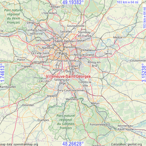
Villeneuve-Saint-Georges GPS coordinates[2]
48° 43' 55.884" North, 2° 26' 57.3" East
| Map corner | latitude | longitude |
|---|---|---|
| Upper-left | 49.19382°, | 1.74613° |
| Center: | 48.73219°, | 2.44925° |
| Lower-right: | 48.26628°, | 3.15238° |
| Map W x H: | 103.1×103.1 km | = 64.1×64.1mi |
| max Lat: | 51.07786° ⇑26.1% North |
| Villeneuve-Saint-Georges: | 48.73219° |
| min Lat: | ⇓73.9% South 41.3874° |
| min Long | Villeneuve-Sain | max Long |
| -5.08615° | 2.44925° | 9.52242° |
| W 49.8%⇐ | ⇒50.2% E |
Elevation
Elevation of Villeneuve-Saint-Georges is 35 m = 115 ft, and this is 158.7 m = 521 ft below average elevation for this country.
| Max E: |
2333 m = 7654 ft | 87.8% |
| Avg. | 193.7 m = 635 ft | |
| Villeneuve-Saint-Georges | 35 m = 115 ft | |
Min E: |
-1 m = -3 ft | 12.2% |
See also: France elevation on elevation.city.
Geographical zone
Villeneuve-Saint-Georges is located in North temperate zone (between Tropic of Cancer and the Arctic Circle). Distance of this North polar circle is 1982.7 km =1232 mi to North.| Distance of | km | miles | from Villeneuve-Saint-Georges |
|---|---|---|---|
| North Pole | 4588.6 | 2851.2 | to North |
| Arctic Circle | 1982.7 | 1232 | to North |
| Tropic Cancer | 2812.6 | 1747.7 | to South |
| Equator | 5418.5 | 3366.9 | to South |


Nearby cities:
15 places around Villeneuve-Saint-Georges: (largest is in red/bold)
• Ablon-sur-Seine
1.7 km =1.1 mi,  251°
251°
• Athis-Mons
5.2 km =3.2 mi,  234°
234°
• Boissy-Saint-Léger
5.1 km =3.2 mi,  64°
64°
• Bonneuil-sur-Marne
4.7 km =2.9 mi,  27°
27°
• Brunoy
5.3 km =3.3 mi,  143°
143°
• Choisy-le-Roi
4.6 km =2.9 mi,  330°
330°
• Crosne
1.6 km =1 mi,  157°
157°
• Limeil-Brévannes
3.1 km =1.9 mi, 63°
• Montgeron
3 km =1.9 mi,  178°
178°
• Orly
4.5 km =2.8 mi,  292°
292°
• Thiais
5.3 km =3.3 mi,  313°
313°
• Valenton
1.8 km =1.1 mi,  37°
37°
• Vigneux-sur-Seine
4.2 km =2.6 mi,  218°
218°
• Villeneuve-le-Roi
3.6 km =2.2 mi,  278°
278°
• Yerres
3.6 km =2.2 mi,  116°
116°
Sources, notices
• [Note1] Compared only with cities in France existing in our database
• [Src1] Map data: © OpenStreetMap contributors (CC-BY-SA)
• [Src2] Other city data from geonames.org with taken over terms of usage.
• [Src3] Geographical zone / Annual Mean Temperature by Robert A. Rohde @ Wikipedia
