Rungis geodata
Rungis (Île-de-France) is a populated place; located in France in Europe/Paris (GMT+2) time zone. With population of 5,583 people, there are 1774 cities with bigger population in this country. Compared to other cities in France, 74.2% of cities are located further ↓South; 51.8% of cities are located further →East and 66.6% of cities have higher elevation than Rungis. Note1
Administrative division(s):
- Level 1: Île-de-France
- Level 2: Val-de-Marne
- Level 3: Arrondissement de L'Haÿ-les-Roses
- Level 4: Rungis


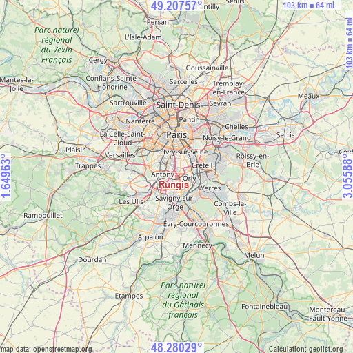
Rungis GPS coordinates[2]
48° 44' 45.852" North, 2° 21' 9.9" East
| Map corner | latitude | longitude |
|---|---|---|
| Upper-left | 49.20757°, | 1.64963° |
| Center: | 48.74607°, | 2.35275° |
| Lower-right: | 48.28029°, | 3.05588° |
| Map W x H: | 103.1×103.1 km | = 64.1×64.1mi |
| max Lat: | 51.07786° ⇑25.8% North |
| Rungis: | 48.74607° |
| min Lat: | ⇓74.2% South 41.3874° |
| min Long | Rungis | max Long |
| -5.08615° | 2.35275° | 9.52242° |
| W 48.2%⇐ | ⇒51.8% E |
Elevation
Elevation of Rungis is 86 m = 282 ft, and this is 107.7 m = 353 ft below average elevation for this country.
| Max E: |
2333 m = 7654 ft | 66.6% |
| Avg. | 193.7 m = 635 ft | |
| Rungis | 86 m = 282 ft | |
Min E: |
-1 m = -3 ft | 33.4% |
See also: France elevation on elevation.city.
Geographical zone
Rungis is located in North temperate zone (between Tropic of Cancer and the Arctic Circle). Distance of this North polar circle is 1981.1 km =1231 mi to North.| Distance of | km | miles | from Rungis |
|---|---|---|---|
| North Pole | 4587 | 2850.2 | to North |
| Arctic Circle | 1981.1 | 1231 | to North |
| Tropic Cancer | 2814.1 | 1748.6 | to South |
| Equator | 5420.1 | 3367.9 | to South |


Nearby cities:
15 places around Rungis: (largest is in red/bold)
• Antony
4.2 km =2.6 mi,  281°
281°
• Athis-Mons
5.4 km =3.4 mi,  147°
147°
• Bourg-la-Reine
4.5 km =2.8 mi,  324°
324°
• Chevilly-Larue
2.1 km =1.3 mi,  355°
355°
• Chilly-Mazarin
4.4 km =2.7 mi,  217°
217°
• Choisy-le-Roi
5.4 km =3.4 mi,  62°
62°
• Fresnes
2.5 km =1.6 mi,  295°
295°
• L'Haÿ-les-Roses
4.4 km =2.7 mi,  341°
341°
• Morangis
4.8 km =3 mi,  192°
192°
• Orly
2.9 km =1.8 mi,  85°
85°
• Paray-Vieille-Poste
3.6 km =2.2 mi,  168°
168°
• Thiais
3.8 km =2.4 mi, 56°
• Villejuif
5.3 km =3.3 mi,  5°
5°
• Villeneuve-le-Roi
3.7 km =2.3 mi,  106°
106°
• Wissous
2.6 km =1.6 mi,  237°
237°
Sources, notices
• [Note1] Compared only with cities in France existing in our database
• [Src1] Map data: © OpenStreetMap contributors (CC-BY-SA)
• [Src2] Other city data from geonames.org with taken over terms of usage.
• [Src3] Geographical zone / Annual Mean Temperature by Robert A. Rohde @ Wikipedia
