Aspach geodata
Aspach (Grand Est) is a populated place; located in France in Europe/Paris (GMT+2) time zone. With population of 1,030 people, there are 8614 cities with bigger population in this country. Compared to other cities in France, 53.3% of cities are located further ↓South; 96% of cities are located further ←West and 80.7% of cities have lower elevation than Aspach. Note1


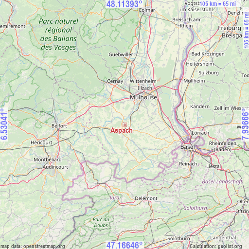
Aspach GPS coordinates[2]
47° 38' 32.424" North, 7° 14' 0.708" East
| Map corner | latitude | longitude |
|---|---|---|
| Upper-left | 48.11393°, | 6.53041° |
| Center: | 47.64234°, | 7.23353° |
| Lower-right: | 47.16646°, | 7.93666° |
| Map W x H: | 105.3×105.3 km | = 65.4×65.4mi |
| max Lat: | 51.07786° ⇑46.7% North |
| Aspach: | 47.64234° |
| min Lat: | ⇓53.3% South 41.3874° |
| min Long | Aspach | max Long |
| -5.08615° | 7.23353° | 9.52242° |
| W 96%⇐ | ⇒4% E |
Elevation
Elevation of Aspach is 298 m = 978 ft, and this is 104.3 m = 342 ft above average elevation for this country.
| Max E: |
2333 m = 7654 ft | 19.3% |
| Aspach | 298 m 978 ft | |
| Avg. | 193.7 m = 635 ft | |
Min E: |
-1 m = -3 ft | 80.7% |
See also: France elevation on elevation.city.
Geographical zone
Aspach is located in North temperate zone (between Tropic of Cancer and the Arctic Circle). Distance of this North polar circle is 2103.8 km =1307.2 mi to North.| Distance of | km | miles | from Aspach |
|---|---|---|---|
| North Pole | 4709.7 | 2926.5 | to North |
| Arctic Circle | 2103.8 | 1307.2 | to North |
| Tropic Cancer | 2691.4 | 1672.4 | to South |
| Equator | 5297.3 | 3291.6 | to South |


Nearby cities:
15 places around Aspach: (largest is in red/bold)
• Altkirch
2.1 km =1.3 mi,  167°
167°
• Ballersdorf
5.8 km =3.6 mi,  249°
249°
• Balschwiller
5.8 km =3.6 mi,  303°
303°
• Carspach
3.4 km =2.1 mi,  210°
210°
• Frœningen
5.2 km =3.2 mi,  28°
28°
• Hagenbach
5.7 km =3.5 mi,  277°
277°
• Heidwiller
1.9 km =1.2 mi,  12°
12°
• Hirtzbach
5 km =3.1 mi,  189°
189°
• Illfurth
4.3 km =2.7 mi, 34°
• Luemschwiller
4.3 km =2.7 mi,  71°
71°
• Spechbach-le-Bas
3.1 km =1.9 mi,  351°
351°
• Spechbach-le-Haut
4.6 km =2.9 mi,  343°
343°
• Tagolsheim
3.2 km =2 mi,  59°
59°
• Walheim
2.5 km =1.6 mi,  88°
88°
• Wittersdorf
3.8 km =2.4 mi,  125°
125°
Sources, notices
• [Note1] Compared only with cities in France existing in our database
• [Src1] Map data: © OpenStreetMap contributors (CC-BY-SA)
• [Src2] Other city data from geonames.org with taken over terms of usage.
• [Src3] Geographical zone / Annual Mean Temperature by Robert A. Rohde @ Wikipedia
