Chaumontel geodata
Chaumontel (Île-de-France) is a populated place; located in France in Europe/Paris (GMT+2) time zone. With population of 3,278 people, there are 2973 cities with bigger population in this country. Compared to other cities in France, 82.7% of cities are located further ↓South; 50.5% of cities are located further →East and 81.5% of cities have higher elevation than Chaumontel. Note1
Administrative division(s):
- Level 1: Île-de-France
- Level 2: Département du Val-d’Oise
- Level 3: Arrondissement de Sarcelles
- Level 4: Chaumontel


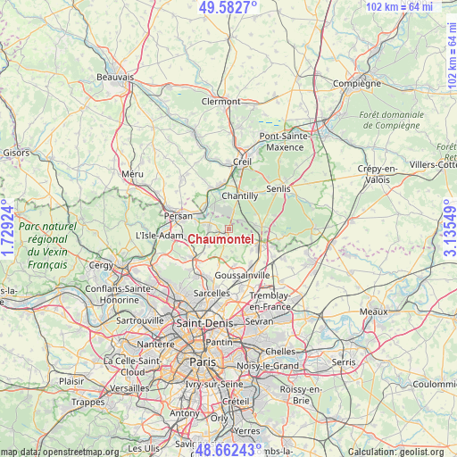
Chaumontel GPS coordinates[2]
49° 7' 28.92" North, 2° 25' 56.532" East
| Map corner | latitude | longitude |
|---|---|---|
| Upper-left | 49.5827°, | 1.72924° |
| Center: | 49.1247°, | 2.43237° |
| Lower-right: | 48.66243°, | 3.13549° |
| Map W x H: | 102.3×102.3 km | = 63.6×63.6mi |
| max Lat: | 51.07786° ⇑17.3% North |
| Chaumontel: | 49.1247° |
| min Lat: | ⇓82.7% South 41.3874° |
| min Long | Chaumontel | max Long |
| -5.08615° | 2.43237° | 9.52242° |
| W 49.5%⇐ | ⇒50.5% E |
Elevation
Elevation of Chaumontel is 51 m = 167 ft, and this is 142.7 m = 468 ft below average elevation for this country.
| Max E: |
2333 m = 7654 ft | 81.5% |
| Avg. | 193.7 m = 635 ft | |
| Chaumontel | 51 m = 167 ft | |
Min E: |
-1 m = -3 ft | 18.5% |
See also: France elevation on elevation.city.
Geographical zone
Chaumontel is located in North temperate zone (between Tropic of Cancer and the Arctic Circle). Distance of this North polar circle is 1939 km =1204.8 mi to North.| Distance of | km | miles | from Chaumontel |
|---|---|---|---|
| North Pole | 4544.9 | 2824.1 | to North |
| Arctic Circle | 1939 | 1204.8 | to North |
| Tropic Cancer | 2856.2 | 1774.8 | to South |
| Equator | 5462.2 | 3394.1 | to South |


Nearby cities:
15 places around Chaumontel: (largest is in red/bold)
• Asnières-sur-Oise
5.7 km =3.5 mi,  280°
280°
• Bellefontaine
3.9 km =2.4 mi,  140°
140°
• Belloy-en-France
6 km =3.7 mi,  227°
227°
• Boran-sur-Oise
7.2 km =4.5 mi,  311°
311°
• Coye-la-Forêt
3.4 km =2.1 mi,  54°
54°
• Fosses
6.4 km =4 mi,  117°
117°
• Gouvieux
7.1 km =4.4 mi,  349°
349°
• Lamorlaye
4.3 km =2.7 mi,  14°
14°
• Luzarches
1.5 km =0.9 mi,  209°
209°
• Mareil-en-France
6.2 km =3.9 mi,  184°
184°
• Marly-la-Ville
7 km =4.3 mi,  132°
132°
• Orry-la-Ville
5.8 km =3.6 mi,  80°
80°
• Saint-Martin-du-Tertre
6.6 km =4.1 mi,  253°
253°
• Seugy
2.8 km =1.7 mi,  263°
263°
• Viarmes
4.5 km =2.8 mi, 278°
Sources, notices
• [Note1] Compared only with cities in France existing in our database
• [Src1] Map data: © OpenStreetMap contributors (CC-BY-SA)
• [Src2] Other city data from geonames.org with taken over terms of usage.
• [Src3] Geographical zone / Annual Mean Temperature by Robert A. Rohde @ Wikipedia
