Arles geodata
Arles (Provence-Alpes-Côte d'Azur) is a seat of a third-order administrative division; located in France in Europe/Paris (GMT+2) time zone. With population of 53,431 people, there are 106 cities with bigger population in this country. Compared to other cities in France, 90.8% of cities are located further ↑North; 73.1% of cities are located further ←West and 92.4% of cities have higher elevation than Arles. Note1
Administrative division(s):
- Level 1: Provence-Alpes-Côte d'Azur
- Level 2: Département des Bouches-du-Rhône
- Level 3: Arles
- Level 4: Arles


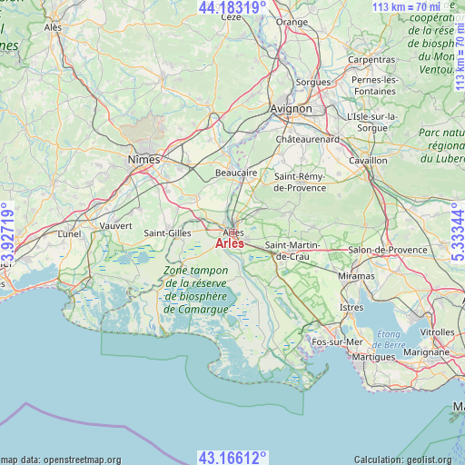
Arles GPS coordinates[2]
43° 40' 36.516" North, 4° 37' 49.116" East
| Map corner | latitude | longitude |
|---|---|---|
| Upper-left | 44.18319°, | 3.92719° |
| Center: | 43.67681°, | 4.63031° |
| Lower-right: | 43.16612°, | 5.33344° |
| Map W x H: | 113.1×113.1 km | = 70.3×70.3mi |
| max Lat: | 51.07786° ⇑90.8% North |
| Arles: | 43.67681° |
| min Lat: | ⇓9.2% South 41.3874° |
| min Long | Arles | max Long |
| -5.08615° | 4.63031° | 9.52242° |
| W 73.1%⇐ | ⇒26.9% E |
Elevation
Elevation of Arles is 24 m = 79 ft, and this is 169.7 m = 557 ft below average elevation for this country.
| Max E: |
2333 m = 7654 ft | 92.4% |
| Avg. | 193.7 m = 635 ft | |
| Arles | 24 m = 79 ft | |
Min E: |
-1 m = -3 ft | 7.6% |
See also: Arles elevation on elevation.city.
Geographical zone
Arles is located in North temperate zone (between Tropic of Cancer and the Arctic Circle). Distance of this Northern Tropic circle is 2250.5 km =1398.4 mi to South.| Distance of | km | miles | from Arles |
|---|---|---|---|
| North Pole | 5150.7 | 3200.5 | to North |
| Arctic Circle | 2544.8 | 1581.3 | to North |
| Tropic Cancer | 2250.5 | 1398.4 | to South |
| Equator | 4856.4 | 3017.6 | to South |


Nearby cities:
15 places around Arles: (largest is in red/bold)
• Beaucaire
14.6 km =9.1 mi,  4°
4°
• Bellegarde
12.5 km =7.8 mi,  312°
312°
• Comps
19.7 km =12.2 mi,  354°
354°
• Fontvieille
8.5 km =5.3 mi,  48°
48°
• Fourques
2.6 km =1.6 mi,  319°
319°
• Garons
19.2 km =11.9 mi,  302°
302°
• Jonquières-Saint-Vincent
17.7 km =11 mi,  342°
342°
• Maussane-les-Alpilles
14.9 km =9.3 mi,  70°
70°
• Mouriès
19.4 km =12.1 mi,  85°
85°
• Paradou
13.3 km =8.3 mi, 70°
• Saint-Gilles
16.1 km =10 mi,  269°
269°
• Saint-Martin-de-Crau
15.2 km =9.4 mi,  105°
105°
• Saint-Étienne-du-Grès
13.8 km =8.6 mi,  33°
33°
• Tarascon
14.5 km =9 mi,  9°
9°
• Vallabrègues
19.6 km =12.2 mi,  359°
359°
Sources, notices
• [Note1] Compared only with cities in France existing in our database
• [Src1] Map data: © OpenStreetMap contributors (CC-BY-SA)
• [Src2] Other city data from geonames.org with taken over terms of usage.
• [Src3] Geographical zone / Annual Mean Temperature by Robert A. Rohde @ Wikipedia
