Hadol geodata
Hadol (Grand Est) is a populated place; located in France in Europe/Paris (GMT+2) time zone. With population of 2,184 people, there are 4397 cities with bigger population in this country. Compared to other cities in France, 61% of cities are located further ↓South; 91.6% of cities are located further ←West and 88.9% of cities have lower elevation than Hadol. Note1
Administrative division(s):
- Level 1: Grand Est
- Level 2: Vosges
- Level 3: Arrondissement d’Épinal
- Level 4: Hadol


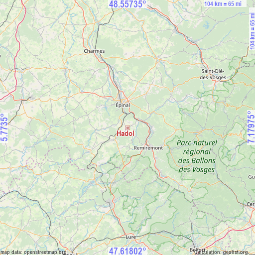
Hadol GPS coordinates[2]
48° 5' 23.388" North, 6° 28' 35.832" East
| Map corner | latitude | longitude |
|---|---|---|
| Upper-left | 48.55735°, | 5.7735° |
| Center: | 48.08983°, | 6.47662° |
| Lower-right: | 47.61802°, | 7.17975° |
| Map W x H: | 104.4×104.4 km | = 64.9×64.9mi |
| max Lat: | 51.07786° ⇑39% North |
| Hadol: | 48.08983° |
| min Lat: | ⇓61% South 41.3874° |
| min Long | Hadol | max Long |
| -5.08615° | 6.47662° | 9.52242° |
| W 91.6%⇐ | ⇒8.4% E |
Elevation
Elevation of Hadol is 406 m = 1332 ft, and this is 212.3 m = 697 ft above average elevation for this country.
| Max E: |
2333 m = 7654 ft | 11.1% |
| Hadol | 406 m 1332 ft | |
| Avg. | 193.7 m = 635 ft | |
Min E: |
-1 m = -3 ft | 88.9% |
See also: France elevation on elevation.city.
Geographical zone
Hadol is located in North temperate zone (between Tropic of Cancer and the Arctic Circle). Distance of this North polar circle is 2054.1 km =1276.4 mi to North.| Distance of | km | miles | from Hadol |
|---|---|---|---|
| North Pole | 4660 | 2895.6 | to North |
| Arctic Circle | 2054.1 | 1276.4 | to North |
| Tropic Cancer | 2741.2 | 1703.3 | to South |
| Equator | 5347.1 | 3322.5 | to South |


Nearby cities:
15 places around Hadol: (largest is in red/bold)
• Arches
5 km =3.1 mi,  50°
50°
• Archettes
5.8 km =3.6 mi, 50°
• Bellefontaine
8.9 km =5.5 mi,  196°
196°
• Chantraine
9.6 km =6 mi,  341°
341°
• Cheniménil
10.9 km =6.8 mi,  59°
59°
• Dounoux
2.9 km =1.8 mi,  304°
304°
• La Baffe
10.8 km =6.7 mi,  42°
42°
• Pouxeux
7.4 km =4.6 mi,  75°
75°
• Raon-aux-Bois
4.9 km =3 mi,  138°
138°
• Saint-Nabord
8.9 km =5.5 mi,  118°
118°
• Uriménil
5.8 km =3.6 mi,  282°
282°
• Uzemain
9.8 km =6.1 mi,  267°
267°
• Xertigny
7.2 km =4.5 mi,  224°
224°
• Éloyes
9.7 km =6 mi, 84°
• Épinal
10.5 km =6.5 mi,  350°
350°
Sources, notices
• [Note1] Compared only with cities in France existing in our database
• [Src1] Map data: © OpenStreetMap contributors (CC-BY-SA)
• [Src2] Other city data from geonames.org with taken over terms of usage.
• [Src3] Geographical zone / Annual Mean Temperature by Robert A. Rohde @ Wikipedia
