Althen-des-Paluds geodata
Althen-des-Paluds (Provence-Alpes-Côte d'Azur) is a populated place; located in France in Europe/Paris (GMT+2) time zone. With population of 2,125 people, there are 4530 cities with bigger population in this country. Compared to other cities in France, 87.1% of cities are located further ↑North; 77.2% of cities are located further ←West and 88.6% of cities have higher elevation than Althen-des-Paluds. Note1
Administrative division(s):
- Level 1: Provence-Alpes-Côte d'Azur
- Level 2: Département du Vaucluse
- Level 3: Arrondissement de Carpentras
- Level 4: Althen-des-Paluds


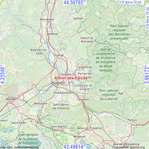
Althen-des-Paluds GPS coordinates[2]
44° 0' 14.58" North, 4° 57' 30.996" East
| Map corner | latitude | longitude |
|---|---|---|
| Upper-left | 44.50765°, | 4.25548° |
| Center: | 44.00405°, | 4.95861° |
| Lower-right: | 43.49614°, | 5.66173° |
| Map W x H: | 112.5×112.5 km | = 69.9×69.9mi |
| max Lat: | 51.07786° ⇑87.1% North |
| Althen-des-Paluds: | 44.00405° |
| min Lat: | ⇓12.9% South 41.3874° |
| min Long | Althen-des-Palu | max Long |
| -5.08615° | 4.95861° | 9.52242° |
| W 77.2%⇐ | ⇒22.8% E |
Elevation
Elevation of Althen-des-Paluds is 33 m = 108 ft, and this is 160.7 m = 527 ft below average elevation for this country.
| Max E: |
2333 m = 7654 ft | 88.6% |
| Avg. | 193.7 m = 635 ft | |
| Althen-des-Paluds | 33 m = 108 ft | |
Min E: |
-1 m = -3 ft | 11.4% |
See also: France elevation on elevation.city.
Geographical zone
Althen-des-Paluds is located in North temperate zone (between Tropic of Cancer and the Arctic Circle). Distance of this Northern Tropic circle is 2286.9 km =1421 mi to South.| Distance of | km | miles | from Althen-des-Paluds |
|---|---|---|---|
| North Pole | 5114.3 | 3177.9 | to North |
| Arctic Circle | 2508.4 | 1558.6 | to North |
| Tropic Cancer | 2286.9 | 1421 | to South |
| Equator | 4892.8 | 3040.2 | to South |


Nearby cities:
15 places around Althen-des-Paluds: (largest is in red/bold)
• Bédarrides
6.3 km =3.9 mi,  309°
309°
• Carpentras
9.1 km =5.7 mi,  51°
51°
• Châteauneuf-de-Gadagne
8.7 km =5.4 mi,  187°
187°
• Entraigues-sur-la-Sorgue
2.6 km =1.6 mi,  267°
267°
• Jonquerettes
6.7 km =4.2 mi,  197°
197°
• Le Thor
8.8 km =5.5 mi,  160°
160°
• Loriol-du-Comtat
8.7 km =5.4 mi,  22°
22°
• Monteux
4.7 km =2.9 mi,  40°
40°
• Morières-lès-Avignon
8.5 km =5.3 mi,  212°
212°
• Pernes-les-Fontaines
8.1 km =5 mi,  94°
94°
• Saint-Saturnin-lès-Avignon
6.1 km =3.8 mi, 205°
• Sarrians
8.8 km =5.5 mi,  6°
6°
• Sorgues
6.8 km =4.2 mi,  275°
275°
• Vedène
5.3 km =3.3 mi,  235°
235°
• Velleron
7.7 km =4.8 mi,  132°
132°
Sources, notices
• [Note1] Compared only with cities in France existing in our database
• [Src1] Map data: © OpenStreetMap contributors (CC-BY-SA)
• [Src2] Other city data from geonames.org with taken over terms of usage.
• [Src3] Geographical zone / Annual Mean Temperature by Robert A. Rohde @ Wikipedia
