Morières-lès-Avignon geodata
Morières-lès-Avignon (Provence-Alpes-Côte d'Azur) is a populated place; located in France in Europe/Paris (GMT+2) time zone. With population of 7,001 people, there are 1401 cities with bigger population in this country. Compared to other cities in France, 87.6% of cities are located further ↑North; 76.5% of cities are located further ←West and 90.3% of cities have higher elevation than Morières-lès-Avignon. Note1
Administrative division(s):
- Level 1: Provence-Alpes-Côte d'Azur
- Level 2: Département du Vaucluse
- Level 3: Arrondissement d’Avignon
- Level 4: Morières-lès-Avignon
Current local time in Morières-lès-Avignon:
06:04 AM, WednesdayDifference from your time zone: hours


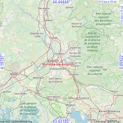
Morières-lès-Avignon GPS coordinates[2]
43° 56' 25.08" North, 4° 54' 3.96" East
| Map corner | latitude | longitude |
|---|---|---|
| Upper-left | 44.44444°, | 4.19797° |
| Center: | 43.9403°, | 4.9011° |
| Lower-right: | 43.43185°, | 5.60422° |
| Map W x H: | 112.6×112.6 km | = 70×70mi |
| max Lat: | 51.07786° ⇑87.6% North |
| Morières-lès-Avignon: | 43.9403° |
| min Lat: | ⇓12.4% South 41.3874° |
| min Long | Morières-lès- | max Long |
| -5.08615° | 4.9011° | 9.52242° |
| W 76.5%⇐ | ⇒23.5% E |
Elevation
Elevation of Morières-lès-Avignon is 29 m = 95 ft, and this is 164.7 m = 540 ft below average elevation for this country.
| Max E: |
2333 m = 7654 ft | 90.3% |
| Avg. | 193.7 m = 635 ft | |
| Morières-lès-Avignon | 29 m = 95 ft | |
Min E: |
-1 m = -3 ft | 9.7% |
See also: France elevation on elevation.city.
Geographical zone
Morières-lès-Avignon is located in North temperate zone (between Tropic of Cancer and the Arctic Circle). Distance of this Northern Tropic circle is 2279.8 km =1416.6 mi to South.| Distance of | km | miles | from Morières-lès-Avignon |
|---|---|---|---|
| North Pole | 5121.4 | 3182.3 | to North |
| Arctic Circle | 2515.5 | 1563.1 | to North |
| Tropic Cancer | 2279.8 | 1416.6 | to South |
| Equator | 4885.7 | 3035.8 | to South |


Nearby cities:
15 places around Morières-lès-Avignon: (largest is in red/bold)
• Althen-des-Paluds
8.5 km =5.3 mi,  32°
32°
• Avignon
7.4 km =4.6 mi,  276°
276°
• Caumont-sur-Durance
6.4 km =4 mi,  144°
144°
• Châteauneuf-de-Gadagne
3.8 km =2.4 mi,  113°
113°
• Châteaurenard
7.5 km =4.7 mi,  209°
209°
• Entraigues-sur-la-Sorgue
7.3 km =4.5 mi,  16°
16°
• Jonquerettes
2.6 km =1.6 mi,  74°
74°
• Le Pontet
4 km =2.5 mi,  305°
305°
• Le Thor
7.6 km =4.7 mi,  99°
99°
• Montfavet
2.3 km =1.4 mi,  250°
250°
• Noves
7 km =4.3 mi,  179°
179°
• Rognonas
9 km =5.6 mi,  240°
240°
• Saint-Saturnin-lès-Avignon
2.5 km =1.6 mi,  50°
50°
• Sorgues
8.1 km =5 mi,  344°
344°
• Vedène
4.1 km =2.5 mi,  3°
3°
Sources, notices
• [Note1] Compared only with cities in France existing in our database
• [Src1] Map data: © OpenStreetMap contributors (CC-BY-SA)
• [Src2] Other city data from geonames.org with taken over terms of usage.
• [Src3] Geographical zone / Annual Mean Temperature by Robert A. Rohde @ Wikipedia
