Sorgues geodata
Sorgues (Provence-Alpes-Côte d'Azur) is a populated place; located in France in Europe/Paris (GMT+2) time zone. With population of 18,681 people, there are 500 cities with bigger population in this country. Compared to other cities in France, 87% of cities are located further ↑North; 76.1% of cities are located further ←West and 89.9% of cities have higher elevation than Sorgues. Note1
Administrative division(s):
- Level 1: Provence-Alpes-Côte d'Azur
- Level 2: Département du Vaucluse
- Level 3: Arrondissement d’Avignon
- Level 4: Sorgues


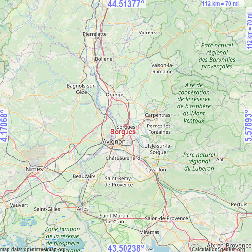
Sorgues GPS coordinates[2]
44° 0' 36.828" North, 4° 52' 25.716" East
| Map corner | latitude | longitude |
|---|---|---|
| Upper-left | 44.51377°, | 4.17068° |
| Center: | 44.01023°, | 4.87381° |
| Lower-right: | 43.50238°, | 5.57693° |
| Map W x H: | 112.5×112.5 km | = 69.9×69.9mi |
| max Lat: | 51.07786° ⇑87% North |
| Sorgues: | 44.01023° |
| min Lat: | ⇓13% South 41.3874° |
| min Long | Sorgues | max Long |
| -5.08615° | 4.87381° | 9.52242° |
| W 76.1%⇐ | ⇒23.9% E |
Elevation
Elevation of Sorgues is 30 m = 98 ft, and this is 163.7 m = 537 ft below average elevation for this country.
| Max E: |
2333 m = 7654 ft | 89.9% |
| Avg. | 193.7 m = 635 ft | |
| Sorgues | 30 m = 98 ft | |
Min E: |
-1 m = -3 ft | 10.1% |
See also: France elevation on elevation.city.
Geographical zone
Sorgues is located in North temperate zone (between Tropic of Cancer and the Arctic Circle). Distance of this Northern Tropic circle is 2287.6 km =1421.4 mi to South.| Distance of | km | miles | from Sorgues |
|---|---|---|---|
| North Pole | 5113.6 | 3177.4 | to North |
| Arctic Circle | 2507.7 | 1558.2 | to North |
| Tropic Cancer | 2287.6 | 1421.4 | to South |
| Equator | 4893.5 | 3040.7 | to South |


Nearby cities:
15 places around Sorgues: (largest is in red/bold)
• Althen-des-Paluds
6.8 km =4.2 mi,  95°
95°
• Avignon
8.6 km =5.3 mi,  217°
217°
• Bédarrides
3.9 km =2.4 mi,  30°
30°
• Châteauneuf-du-Pape
6.1 km =3.8 mi,  327°
327°
• Courthézon
8.6 km =5.3 mi,  5°
5°
• Entraigues-sur-la-Sorgue
4.3 km =2.7 mi, 100°
• Jonquerettes
8.5 km =5.3 mi,  146°
146°
• Le Pontet
5.6 km =3.5 mi,  191°
191°
• Montfavet
8.5 km =5.3 mi,  180°
180°
• Morières-lès-Avignon
8.1 km =5 mi,  164°
164°
• Pujaut
7.9 km =4.9 mi,  264°
264°
• Saint-Saturnin-lès-Avignon
7.4 km =4.6 mi, 146°
• Sauveterre
6.6 km =4.1 mi,  282°
282°
• Vedène
4.4 km =2.7 mi, 146°
• Villeneuve-lès-Avignon
7.8 km =4.8 mi,  233°
233°
Sources, notices
• [Note1] Compared only with cities in France existing in our database
• [Src1] Map data: © OpenStreetMap contributors (CC-BY-SA)
• [Src2] Other city data from geonames.org with taken over terms of usage.
• [Src3] Geographical zone / Annual Mean Temperature by Robert A. Rohde @ Wikipedia
