Albert geodata
Albert (Hauts-de-France) is a populated place; located in France in Europe/Paris (GMT+2) time zone. With population of 10,588 people, there are 900 cities with bigger population in this country. Compared to other cities in France, 93.6% of cities are located further ↓South; 52.8% of cities are located further ←West and 74.1% of cities have higher elevation than Albert. Note1
Administrative division(s):
- Level 1: Hauts-de-France
- Level 2: Somme
- Level 3: Arrondissement de Péronne
- Level 4: Albert


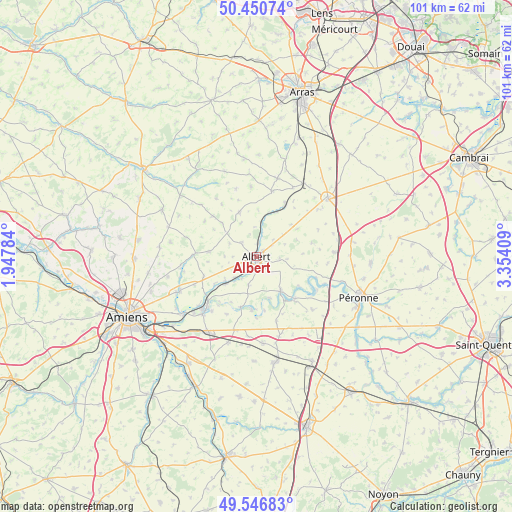
Albert GPS coordinates[2]
50° 0' 3.276" North, 2° 39' 3.456" East
| Map corner | latitude | longitude |
|---|---|---|
| Upper-left | 50.45074°, | 1.94784° |
| Center: | 50.00091°, | 2.65096° |
| Lower-right: | 49.54683°, | 3.35409° |
| Map W x H: | 100.5×100.5 km | = 62.4×62.4mi |
| max Lat: | 51.07786° ⇑6.4% North |
| Albert: | 50.00091° |
| min Lat: | ⇓93.6% South 41.3874° |
| min Long | Albert | max Long |
| -5.08615° | 2.65096° | 9.52242° |
| W 52.8%⇐ | ⇒47.2% E |
Elevation
Elevation of Albert is 69 m = 226 ft, and this is 124.7 m = 409 ft below average elevation for this country.
| Max E: |
2333 m = 7654 ft | 74.1% |
| Avg. | 193.7 m = 635 ft | |
| Albert | 69 m = 226 ft | |
Min E: |
-1 m = -3 ft | 25.9% |
See also: France elevation on elevation.city.
Geographical zone
Albert is located in North temperate zone (between Tropic of Cancer and the Arctic Circle). Distance of this North polar circle is 1841.6 km =1144.3 mi to North.| Distance of | km | miles | from Albert |
|---|---|---|---|
| North Pole | 4447.5 | 2763.5 | to North |
| Arctic Circle | 1841.6 | 1144.3 | to North |
| Tropic Cancer | 2953.7 | 1835.3 | to South |
| Equator | 5559.6 | 3454.6 | to South |


Nearby cities:
15 places around Albert: (largest is in red/bold)
• Acheux-en-Amiénois
11.7 km =7.3 mi,  313°
313°
• Becquincourt
15.5 km =9.6 mi,  130°
130°
• Bouzincourt
4 km =2.5 mi, 313°
• Bray-sur-Somme
8.2 km =5.1 mi,  144°
144°
• Bucquoy
16 km =9.9 mi,  15°
15°
• Combles
15.5 km =9.6 mi,  86°
86°
• Corbie
14.7 km =9.1 mi,  224°
224°
• Ligny-Thilloy
15.4 km =9.6 mi,  52°
52°
• Mailly-Maillet
9.4 km =5.8 mi,  339°
339°
• Miraumont
11.9 km =7.4 mi,  28°
28°
• Méaulte
2.3 km =1.4 mi,  161°
161°
• Proyart
13.3 km =8.3 mi, 162°
• Puisieux
13.2 km =8.2 mi,  13°
13°
• Ribemont-sur-Ancre
8.3 km =5.2 mi,  226°
226°
• Warloy-Baillon
9.3 km =5.8 mi,  276°
276°
Sources, notices
• [Note1] Compared only with cities in France existing in our database
• [Src1] Map data: © OpenStreetMap contributors (CC-BY-SA)
• [Src2] Other city data from geonames.org with taken over terms of usage.
• [Src3] Geographical zone / Annual Mean Temperature by Robert A. Rohde @ Wikipedia
