Combles geodata
Combles (Hauts-de-France) is a populated place; located in France in Europe/Paris (GMT+2) time zone. With population of 695 people, there are 11873 cities with bigger population in this country. Compared to other cities in France, 93.6% of cities are located further ↓South; 55.9% of cities are located further ←West and 60.8% of cities have higher elevation than Combles. Note1
Administrative division(s):
- Level 1: Hauts-de-France
- Level 2: Somme
- Level 3: Arrondissement de Péronne
- Level 4: Combles


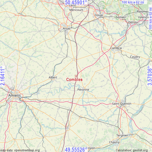
Combles GPS coordinates[2]
50° 0' 33.336" North, 2° 52' 2.064" East
| Map corner | latitude | longitude |
|---|---|---|
| Upper-left | 50.45901°, | 2.16411° |
| Center: | 50.00926°, | 2.86724° |
| Lower-right: | 49.55526°, | 3.57036° |
| Map W x H: | 100.5×100.5 km | = 62.4×62.4mi |
| max Lat: | 51.07786° ⇑6.4% North |
| Combles: | 50.00926° |
| min Lat: | ⇓93.6% South 41.3874° |
| min Long | Combles | max Long |
| -5.08615° | 2.86724° | 9.52242° |
| W 55.9%⇐ | ⇒44.1% E |
Elevation
Elevation of Combles is 100 m = 328 ft, and this is 93.7 m = 307 ft below average elevation for this country.
| Max E: |
2333 m = 7654 ft | 60.8% |
| Avg. | 193.7 m = 635 ft | |
| Combles | 100 m = 328 ft | |
Min E: |
-1 m = -3 ft | 39.2% |
See also: France elevation on elevation.city.
Geographical zone
Combles is located in North temperate zone (between Tropic of Cancer and the Arctic Circle). Distance of this North polar circle is 1840.7 km =1143.8 mi to North.| Distance of | km | miles | from Combles |
|---|---|---|---|
| North Pole | 4446.6 | 2763 | to North |
| Arctic Circle | 1840.7 | 1143.8 | to North |
| Tropic Cancer | 2954.6 | 1835.9 | to South |
| Equator | 5560.5 | 3455.1 | to South |


Nearby cities:
15 places around Combles: (largest is in red/bold)
• Achiet-le-Grand
14.8 km =9.2 mi,  335°
335°
• Bapaume
10.6 km =6.6 mi,  353°
353°
• Beaumetz-lès-Cambrai
15.1 km =9.4 mi,  33°
33°
• Becquincourt
11.6 km =7.2 mi,  198°
198°
• Bertincourt
11.8 km =7.3 mi,  43°
43°
• Bray-sur-Somme
13.1 km =8.1 mi,  234°
234°
• Cartigny
15 km =9.3 mi,  136°
136°
• Cléry-sur-Somme
6 km =3.7 mi,  166°
166°
• Doingt
12.1 km =7.5 mi, 143°
• Heudicourt
15.3 km =9.5 mi,  84°
84°
• Ligny-Thilloy
9 km =5.6 mi, 339°
• Miraumont
13.6 km =8.5 mi,  314°
314°
• Moislains
7.3 km =4.5 mi,  108°
108°
• Méaulte
15 km =9.3 mi,  258°
258°
• Péronne
9.9 km =6.2 mi,  150°
150°
Sources, notices
• [Note1] Compared only with cities in France existing in our database
• [Src1] Map data: © OpenStreetMap contributors (CC-BY-SA)
• [Src2] Other city data from geonames.org with taken over terms of usage.
• [Src3] Geographical zone / Annual Mean Temperature by Robert A. Rohde @ Wikipedia
