Bucquoy geodata
Bucquoy (Hauts-de-France) is a populated place; located in France in Europe/Paris (GMT+2) time zone. With population of 1,297 people, there are 7046 cities with bigger population in this country. Compared to other cities in France, 94.5% of cities are located further ↓South; 53.7% of cities are located further ←West and 51.4% of cities have higher elevation than Bucquoy. Note1
Administrative division(s):
- Level 1: Hauts-de-France
- Level 2: Pas-de-Calais
- Level 3: Arras
- Level 4: Bucquoy


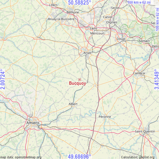
Bucquoy GPS coordinates[2]
50° 8' 23.028" North, 2° 42' 37.296" East
| Map corner | latitude | longitude |
|---|---|---|
| Upper-left | 50.58825°, | 2.00724° |
| Center: | 50.13973°, | 2.71036° |
| Lower-right: | 49.68696°, | 3.41349° |
| Map W x H: | 100.2×100.2 km | = 62.3×62.3mi |
| max Lat: | 51.07786° ⇑5.5% North |
| Bucquoy: | 50.13973° |
| min Lat: | ⇓94.5% South 41.3874° |
| min Long | Bucquoy | max Long |
| -5.08615° | 2.71036° | 9.52242° |
| W 53.7%⇐ | ⇒46.3% E |
Elevation
Elevation of Bucquoy is 127 m = 417 ft, and this is 66.7 m = 219 ft below average elevation for this country.
| Max E: |
2333 m = 7654 ft | 51.4% |
| Avg. | 193.7 m = 635 ft | |
| Bucquoy | 127 m = 417 ft | |
Min E: |
-1 m = -3 ft | 48.6% |
See also: France elevation on elevation.city.
Geographical zone
Bucquoy is located in North temperate zone (between Tropic of Cancer and the Arctic Circle). Distance of this North polar circle is 1826.2 km =1134.7 mi to North.| Distance of | km | miles | from Bucquoy |
|---|---|---|---|
| North Pole | 4432 | 2753.9 | to North |
| Arctic Circle | 1826.2 | 1134.7 | to North |
| Tropic Cancer | 2969.1 | 1844.9 | to South |
| Equator | 5575 | 3464.1 | to South |


Nearby cities:
15 places around Bucquoy: (largest is in red/bold)
• Achiet-le-Grand
5.1 km =3.2 mi,  101°
101°
• Agny
13.7 km =8.5 mi,  14°
14°
• Bapaume
10.7 km =6.6 mi,  111°
111°
• Beaumetz-lès-Loges
11.6 km =7.2 mi,  341°
341°
• Croisilles
13.8 km =8.6 mi,  60°
60°
• Ficheux
9.8 km =6.1 mi, 11°
• Ligny-Thilloy
10 km =6.2 mi,  127°
127°
• Mailly-Maillet
10 km =6.2 mi,  228°
228°
• Mercatel
12.3 km =7.6 mi,  29°
29°
• Miraumont
5.2 km =3.2 mi,  163°
163°
• Neuville-Vitasse
14.4 km =8.9 mi, 33°
• Puisieux
2.8 km =1.7 mi,  203°
203°
• Rivière
10.5 km =6.5 mi,  352°
352°
• Simencourt
14 km =8.7 mi, 339°
• Vaulx-Vraucourt
14.1 km =8.8 mi,  85°
85°
Sources, notices
• [Note1] Compared only with cities in France existing in our database
• [Src1] Map data: © OpenStreetMap contributors (CC-BY-SA)
• [Src2] Other city data from geonames.org with taken over terms of usage.
• [Src3] Geographical zone / Annual Mean Temperature by Robert A. Rohde @ Wikipedia
