Aillas geodata
Aillas (Nouvelle-Aquitaine) is a populated place; located in France in Europe/Paris (GMT+2) time zone. With population of 733 people, there are 11372 cities with bigger population in this country. Compared to other cities in France, 83.8% of cities are located further ↑North; 78.7% of cities are located further →East and 75% of cities have higher elevation than Aillas. Note1
Administrative division(s):
- Level 1: Nouvelle-Aquitaine
- Level 2: Gironde
- Level 3: Arrondissement de Langon
- Level 4: Aillas


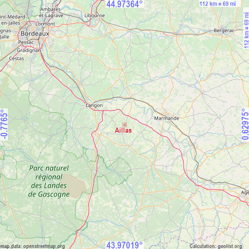
Aillas GPS coordinates[2]
44° 28' 26.652" North, 0° 4' 24.132" West
| Map corner | latitude | longitude |
|---|---|---|
| Upper-left | 44.97364°, | -0.7765° |
| Center: | 44.47407°, | -0.07337° |
| Lower-right: | 43.97019°, | 0.62975° |
| Map W x H: | 111.6×111.6 km | = 69.3×69.3mi |
| max Lat: | 51.07786° ⇑83.8% North |
| Aillas: | 44.47407° |
| min Lat: | ⇓16.2% South 41.3874° |
| min Long | Aillas | max Long |
| -5.08615° | -0.07337° | 9.52242° |
| W 21.3%⇐ | ⇒78.7% E |
Elevation
Elevation of Aillas is 67 m = 220 ft, and this is 126.7 m = 416 ft below average elevation for this country.
| Max E: |
2333 m = 7654 ft | 75% |
| Avg. | 193.7 m = 635 ft | |
| Aillas | 67 m = 220 ft | |
Min E: |
-1 m = -3 ft | 25% |
See also: France elevation on elevation.city.
Geographical zone
Aillas is located in North temperate zone (between Tropic of Cancer and the Arctic Circle). Distance of this Northern Tropic circle is 2339.1 km =1453.4 mi to South.| Distance of | km | miles | from Aillas |
|---|---|---|---|
| North Pole | 5062 | 3145.4 | to North |
| Arctic Circle | 2456.1 | 1526.1 | to North |
| Tropic Cancer | 2339.1 | 1453.4 | to South |
| Equator | 4945.1 | 3072.7 | to South |


Nearby cities:
15 places around Aillas: (largest is in red/bold)
• Auros
6.1 km =3.8 mi,  291°
291°
• Bazas
12 km =7.5 mi,  247°
247°
• Castets-en-Dorthe
11.6 km =7.2 mi,  327°
327°
• Caudrot
12.6 km =7.8 mi, 333°
• Cocumont
8.4 km =5.2 mi,  110°
110°
• Coimères
11 km =6.8 mi,  283°
283°
• Fontet
10.1 km =6.3 mi,  19°
19°
• Gironde-sur-Dropt
12.2 km =7.6 mi,  356°
356°
• Grignols
9.8 km =6.1 mi,  165°
165°
• La Réole
12.3 km =7.6 mi,  13°
13°
• Marcellus
12.1 km =7.5 mi,  86°
86°
• Meilhan-sur-Garonne
10.1 km =6.3 mi,  58°
58°
• Mongauzy
13.3 km =8.3 mi,  39°
39°
• Saint-Martin-de-Sescas
13.3 km =8.3 mi, 328°
• Savignac
6 km =3.7 mi, 332°
Sources, notices
• [Note1] Compared only with cities in France existing in our database
• [Src1] Map data: © OpenStreetMap contributors (CC-BY-SA)
• [Src2] Other city data from geonames.org with taken over terms of usage.
• [Src3] Geographical zone / Annual Mean Temperature by Robert A. Rohde @ Wikipedia
