Bazas geodata
Bazas (Nouvelle-Aquitaine) is a populated place; located in France in Europe/Paris (GMT+2) time zone. With population of 5,131 people, there are 1914 cities with bigger population in this country. Compared to other cities in France, 84% of cities are located further ↑North; 79.8% of cities are located further →East and 65.3% of cities have higher elevation than Bazas. Note1
Administrative division(s):
- Level 1: Nouvelle-Aquitaine
- Level 2: Gironde
- Level 3: Arrondissement de Langon
- Level 4: Bazas


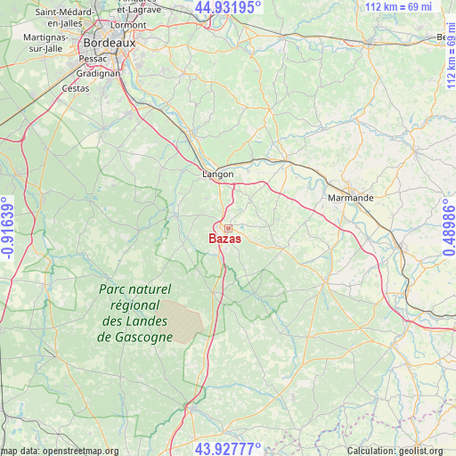
Bazas GPS coordinates[2]
44° 25' 55.272" North, 0° 12' 47.772" West
| Map corner | latitude | longitude |
|---|---|---|
| Upper-left | 44.93195°, | -0.91639° |
| Center: | 44.43202°, | -0.21327° |
| Lower-right: | 43.92777°, | 0.48986° |
| Map W x H: | 111.7×111.7 km | = 69.4×69.4mi |
| max Lat: | 51.07786° ⇑84% North |
| Bazas: | 44.43202° |
| min Lat: | ⇓16% South 41.3874° |
| min Long | Bazas | max Long |
| -5.08615° | -0.21327° | 9.52242° |
| W 20.2%⇐ | ⇒79.8% E |
Elevation
Elevation of Bazas is 89 m = 292 ft, and this is 104.7 m = 344 ft below average elevation for this country.
| Max E: |
2333 m = 7654 ft | 65.3% |
| Avg. | 193.7 m = 635 ft | |
| Bazas | 89 m = 292 ft | |
Min E: |
-1 m = -3 ft | 34.7% |
See also: France elevation on elevation.city.
Geographical zone
Bazas is located in North temperate zone (between Tropic of Cancer and the Arctic Circle). Distance of this Northern Tropic circle is 2334.5 km =1450.6 mi to South.| Distance of | km | miles | from Bazas |
|---|---|---|---|
| North Pole | 5066.7 | 3148.3 | to North |
| Arctic Circle | 2460.8 | 1529.1 | to North |
| Tropic Cancer | 2334.5 | 1450.6 | to South |
| Equator | 4940.4 | 3069.8 | to South |


Nearby cities:
15 places around Bazas: (largest is in red/bold)
• Aillas
12 km =7.5 mi,  67°
67°
• Auros
8.8 km =5.5 mi,  38°
38°
• Coimères
7.2 km =4.5 mi,  2°
2°
• Cudos
5 km =3.1 mi,  185°
185°
• Grignols
14.4 km =8.9 mi,  109°
109°
• Langon
13.8 km =8.6 mi,  347°
347°
• Léogeats
15.1 km =9.4 mi,  306°
306°
• Mazères
7.9 km =4.9 mi,  332°
332°
• Noaillan
13.3 km =8.3 mi,  293°
293°
• Préchac
11.8 km =7.3 mi,  251°
251°
• Roaillan
9.2 km =5.7 mi,  323°
323°
• Saint-Macaire
14.8 km =9.2 mi,  356°
356°
• Savignac
13.1 km =8.1 mi, 39°
• Toulenne
14.4 km =8.9 mi,  344°
344°
• Villandraut
12.9 km =8 mi,  282°
282°
Sources, notices
• [Note1] Compared only with cities in France existing in our database
• [Src1] Map data: © OpenStreetMap contributors (CC-BY-SA)
• [Src2] Other city data from geonames.org with taken over terms of usage.
• [Src3] Geographical zone / Annual Mean Temperature by Robert A. Rohde @ Wikipedia
