Adriers geodata
Adriers (Nouvelle-Aquitaine) is a populated place; located in France in Europe/Paris (GMT+2) time zone. With population of 858 people, there are 10006 cities with bigger population in this country. Compared to other cities in France, 62.8% of cities are located further ↑North; 70.5% of cities are located further →East and 62.9% of cities have lower elevation than Adriers. Note1
Administrative division(s):
- Level 1: Nouvelle-Aquitaine
- Level 2: Vienne
- Level 3: Arrondissement de Montmorillon
- Level 4: Adriers


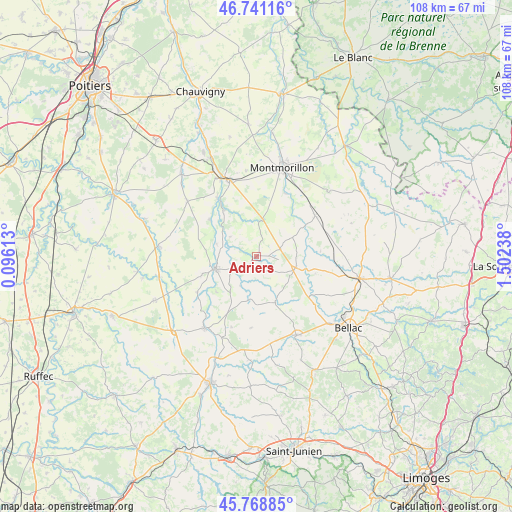
Adriers GPS coordinates[2]
46° 15' 25.776" North, 0° 47' 57.3" East
| Map corner | latitude | longitude |
|---|---|---|
| Upper-left | 46.74116°, | 0.09613° |
| Center: | 46.25716°, | 0.79925° |
| Lower-right: | 45.76885°, | 1.50238° |
| Map W x H: | 108.1×108.1 km | = 67.2×67.2mi |
| max Lat: | 51.07786° ⇑62.8% North |
| Adriers: | 46.25716° |
| min Lat: | ⇓37.2% South 41.3874° |
| min Long | Adriers | max Long |
| -5.08615° | 0.79925° | 9.52242° |
| W 29.5%⇐ | ⇒70.5% E |
Elevation
Elevation of Adriers is 184 m = 604 ft, and this is 9.7 m = 32 ft below average elevation for this country.
| Max E: |
2333 m = 7654 ft | 37.1% |
| Avg. | 193.7 m = 635 ft | |
| Adriers | 184 m = 604 ft | |
Min E: |
-1 m = -3 ft | 62.9% |
See also: France elevation on elevation.city.
Geographical zone
Adriers is located in North temperate zone (between Tropic of Cancer and the Arctic Circle). Distance of this North polar circle is 2257.9 km =1403 mi to North.| Distance of | km | miles | from Adriers |
|---|---|---|---|
| North Pole | 4863.7 | 3022.2 | to North |
| Arctic Circle | 2257.9 | 1403 | to North |
| Tropic Cancer | 2537.4 | 1576.7 | to South |
| Equator | 5143.3 | 3195.9 | to South |


Nearby cities:
15 places around Adriers: (largest is in red/bold)
• Availles-Limouzine
18.8 km =11.7 mi,  216°
216°
• Bussière-Poitevine
8.5 km =5.3 mi,  106°
106°
• Gouex
14.7 km =9.1 mi,  325°
325°
• Lathus-Saint-Rémy
14.9 km =9.3 mi,  54°
54°
• Le Vigeant
12 km =7.5 mi,  252°
252°
• Lussac-les-Châteaux
17.3 km =10.7 mi,  340°
340°
• Mazerolles
18.7 km =11.6 mi, 331°
• Millac
11.4 km =7.1 mi,  229°
229°
• Moussac
9 km =5.6 mi,  286°
286°
• Mézières-sur-Issoire
18.7 km =11.6 mi,  152°
152°
• Persac
12.1 km =7.5 mi,  323°
323°
• Queaux
12.8 km =8 mi,  307°
307°
• Saint-Bonnet-de-Bellac
15.5 km =9.6 mi,  129°
129°
• Saulgé
14.6 km =9.1 mi,  23°
23°
• Sillars
18.2 km =11.3 mi,  352°
352°
Sources, notices
• [Note1] Compared only with cities in France existing in our database
• [Src1] Map data: © OpenStreetMap contributors (CC-BY-SA)
• [Src2] Other city data from geonames.org with taken over terms of usage.
• [Src3] Geographical zone / Annual Mean Temperature by Robert A. Rohde @ Wikipedia
