Serbannes geodata
Serbannes (Auvergne-Rhône-Alpes) is a populated place; located in France in Europe/Paris (GMT+2) time zone. With population of 697 people, there are 11838 cities with bigger population in this country. Compared to other cities in France, 65.1% of cities are located further ↑North; 62.7% of cities are located further ←West and 82.8% of cities have lower elevation than Serbannes. Note1
Administrative division(s):
- Level 1: Auvergne-Rhône-Alpes
- Level 2: Département de l'Allier
- Level 3: Arrondissement de Vichy
- Level 4: Serbannes


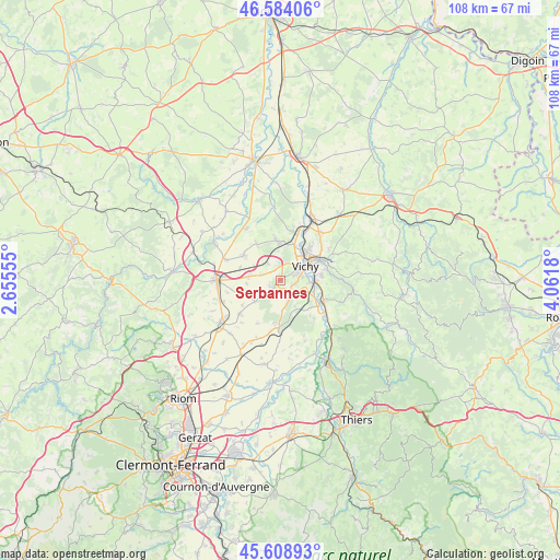
Serbannes GPS coordinates[2]
46° 5' 55.14" North, 3° 21' 31.248" East
| Map corner | latitude | longitude |
|---|---|---|
| Upper-left | 46.58406°, | 2.65555° |
| Center: | 46.09865°, | 3.35868° |
| Lower-right: | 45.60893°, | 4.0618° |
| Map W x H: | 108.4×108.4 km | = 67.4×67.4mi |
| max Lat: | 51.07786° ⇑65.1% North |
| Serbannes: | 46.09865° |
| min Lat: | ⇓34.9% South 41.3874° |
| min Long | Serbannes | max Long |
| -5.08615° | 3.35868° | 9.52242° |
| W 62.7%⇐ | ⇒37.3% E |
Elevation
Elevation of Serbannes is 320 m = 1050 ft, and this is 126.3 m = 414 ft above average elevation for this country.
| Max E: |
2333 m = 7654 ft | 17.2% |
| Serbannes | 320 m 1050 ft | |
| Avg. | 193.7 m = 635 ft | |
Min E: |
-1 m = -3 ft | 82.8% |
See also: France elevation on elevation.city.
Geographical zone
Serbannes is located in North temperate zone (between Tropic of Cancer and the Arctic Circle). Distance of this North polar circle is 2275.5 km =1413.9 mi to North.| Distance of | km | miles | from Serbannes |
|---|---|---|---|
| North Pole | 4881.4 | 3033.2 | to North |
| Arctic Circle | 2275.5 | 1413.9 | to North |
| Tropic Cancer | 2519.8 | 1565.7 | to South |
| Equator | 5125.7 | 3185 | to South |


Nearby cities:
15 places around Serbannes: (largest is in red/bold)
• Abrest
6.6 km =4.1 mi,  90°
90°
• Bellerive-sur-Allier
4 km =2.5 mi,  60°
60°
• Biozat
7.1 km =4.4 mi,  250°
250°
• Brugheas
2.5 km =1.6 mi,  163°
163°
• Charmeil
7.5 km =4.7 mi,  20°
20°
• Cognat-Lyonne
3.9 km =2.4 mi,  285°
285°
• Cusset
8.5 km =5.3 mi, 62°
• Escurolles
8.7 km =5.4 mi,  304°
304°
• Espinasse-Vozelle
4.1 km =2.5 mi,  319°
319°
• Hauterive
6.8 km =4.2 mi,  99°
99°
• Pragoulin
5.6 km =3.5 mi,  151°
151°
• Randan
9 km =5.6 mi,  181°
181°
• Saint-Yorre
8.9 km =5.5 mi,  114°
114°
• Vendat
7.3 km =4.5 mi,  356°
356°
• Vichy
6.1 km =3.8 mi, 58°
Sources, notices
• [Note1] Compared only with cities in France existing in our database
• [Src1] Map data: © OpenStreetMap contributors (CC-BY-SA)
• [Src2] Other city data from geonames.org with taken over terms of usage.
• [Src3] Geographical zone / Annual Mean Temperature by Robert A. Rohde @ Wikipedia
