Mercurey geodata
Mercurey (Bourgogne-Franche-Comté) is a populated place; located in France in Europe/Paris (GMT+1) time zone. With population of 1,310 people, there are 6980 cities with bigger population in this country. Compared to other cities in France, 56.8% of cities are located further ↑North; 74% of cities are located further ←West and 76.2% of cities have lower elevation than Mercurey. Note1
Administrative division(s):
- Level 1: Bourgogne-Franche-Comté
- Level 2: Département de Saône-et-Loire
- Level 3: Arrondissement de Chalon-sur-Saône
- Level 4: Mercurey


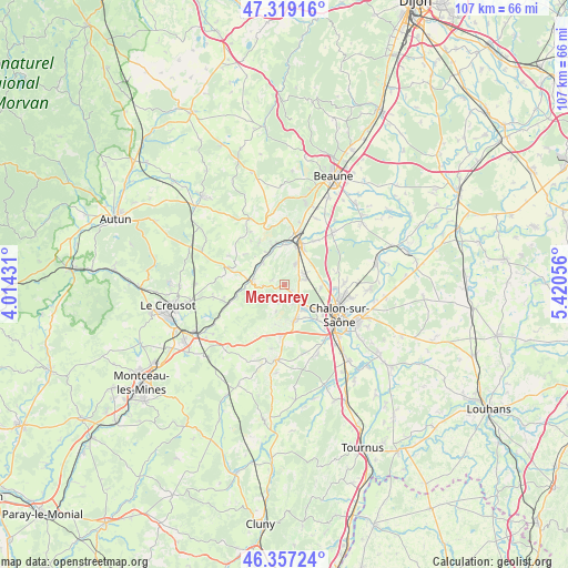
Mercurey GPS coordinates[2]
46° 50' 25.26" North, 4° 43' 2.748" East
| Map corner | latitude | longitude |
|---|---|---|
| Upper-left | 47.31916°, | 4.01431° |
| Center: | 46.84035°, | 4.71743° |
| Lower-right: | 46.35724°, | 5.42056° |
| Map W x H: | 107×107 km | = 66.5×66.5mi |
| max Lat: | 51.07786° ⇑56.8% North |
| Mercurey: | 46.84035° |
| min Lat: | ⇓43.2% South 41.3874° |
| min Long | Mercurey | max Long |
| -5.08615° | 4.71743° | 9.52242° |
| W 74%⇐ | ⇒26% E |
Elevation
Elevation of Mercurey is 258 m = 846 ft, and this is 64.3 m = 211 ft above average elevation for this country.
| Max E: |
2333 m = 7654 ft | 23.8% |
| Mercurey | 258 m 846 ft | |
| Avg. | 193.7 m = 635 ft | |
Min E: |
-1 m = -3 ft | 76.2% |
See also: France elevation on elevation.city.
Geographical zone
Mercurey is located in North temperate zone (between Tropic of Cancer and the Arctic Circle). Distance of this North polar circle is 2193 km =1362.7 mi to North.| Distance of | km | miles | from Mercurey |
|---|---|---|---|
| North Pole | 4798.9 | 2981.9 | to North |
| Arctic Circle | 2193 | 1362.7 | to North |
| Tropic Cancer | 2602.2 | 1616.9 | to South |
| Equator | 5208.2 | 3236.2 | to South |


Nearby cities:
15 places around Mercurey: (largest is in red/bold)
• Chagny
8.1 km =5 mi,  18°
18°
• Champforgeuil
9.2 km =5.7 mi,  105°
105°
• Châtenoy-le-Royal
8.6 km =5.3 mi,  123°
123°
• Dracy-le-Fort
5.9 km =3.7 mi,  144°
144°
• Farges-lès-Chalon
6.9 km =4.3 mi,  95°
95°
• Fontaines
4.1 km =2.5 mi,  76°
76°
• Fragnes
9.7 km =6 mi,  92°
92°
• Givry
6.8 km =4.2 mi,  163°
163°
• Lessard-le-National
9.6 km =6 mi,  72°
72°
• Mellecey
3.4 km =2.1 mi,  165°
165°
• Rully
4.3 km =2.7 mi,  26°
26°
• Saint-Désert
9.6 km =6 mi,  183°
183°
• Saint-Léger-sur-Dheune
6.2 km =3.9 mi,  275°
275°
• Saint-Sernin-du-Plain
9.6 km =6 mi,  306°
306°
• Santenay
8.2 km =5.1 mi,  348°
348°
Sources, notices
• [Note1] Compared only with cities in France existing in our database
• [Src1] Map data: © OpenStreetMap contributors (CC-BY-SA)
• [Src2] Other city data from geonames.org with taken over terms of usage.
• [Src3] Geographical zone / Annual Mean Temperature by Robert A. Rohde @ Wikipedia
