Saint-Léger-sur-Dheune geodata
Saint-Léger-sur-Dheune (Bourgogne-Franche-Comté) is a populated place; located in France in Europe/Paris (GMT+2) time zone. With population of 1,317 people, there are 6949 cities with bigger population in this country. Compared to other cities in France, 56.7% of cities are located further ↑North; 73.1% of cities are located further ←West and 73.3% of cities have lower elevation than Saint-Léger-sur-Dheune. Note1
Administrative division(s):
- Level 1: Bourgogne-Franche-Comté
- Level 2: Département de Saône-et-Loire
- Level 3: Arrondissement de Chalon-sur-Saône
- Level 4: Saint-Léger-sur-Dheune
Current local time in Saint-Léger-sur-Dheune:
11:32 AM, SaturdayDifference from your time zone: hours


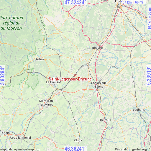
Saint-Léger-sur-Dheune GPS coordinates[2]
46° 50' 43.728" North, 4° 38' 9.852" East
| Map corner | latitude | longitude |
|---|---|---|
| Upper-left | 47.32424°, | 3.93294° |
| Center: | 46.84548°, | 4.63607° |
| Lower-right: | 46.36241°, | 5.33919° |
| Map W x H: | 106.9×106.9 km | = 66.4×66.4mi |
| max Lat: | 51.07786° ⇑56.7% North |
| Saint-Léger-sur-Dheune: | 46.84548° |
| min Lat: | ⇓43.3% South 41.3874° |
| min Long | Saint-Léger-su | max Long |
| -5.08615° | 4.63607° | 9.52242° |
| W 73.1%⇐ | ⇒26.9% E |
Elevation
Elevation of Saint-Léger-sur-Dheune is 238 m = 781 ft, and this is 44.3 m = 145 ft above average elevation for this country.
| Max E: |
2333 m = 7654 ft | 26.7% |
| Saint-Léger-sur-Dheune | 238 m 781 ft | |
| Avg. | 193.7 m = 635 ft | |
Min E: |
-1 m = -3 ft | 73.3% |
See also: France elevation on elevation.city.
Geographical zone
Saint-Léger-sur-Dheune is located in North temperate zone (between Tropic of Cancer and the Arctic Circle). Distance of this North polar circle is 2192.4 km =1362.3 mi to North.| Distance of | km | miles | from Saint-Léger-sur-Dheune |
|---|---|---|---|
| North Pole | 4798.3 | 2981.5 | to North |
| Arctic Circle | 2192.4 | 1362.3 | to North |
| Tropic Cancer | 2602.8 | 1617.3 | to South |
| Equator | 5208.7 | 3236.5 | to South |


Nearby cities:
15 places around Saint-Léger-sur-Dheune: (largest is in red/bold)
• Chagny
11.3 km =7 mi,  51°
51°
• Couches
5.8 km =3.6 mi,  294°
294°
• Dracy-le-Fort
11 km =6.8 mi,  119°
119°
• Fontaines
10.2 km =6.3 mi,  87°
87°
• Givry
10.7 km =6.6 mi,  131°
131°
• Mellecey
8 km =5 mi, 118°
• Mercurey
6.2 km =3.9 mi,  95°
95°
• Moroges
11 km =6.8 mi,  163°
163°
• Nolay
11.8 km =7.3 mi,  359°
359°
• Rully
8.8 km =5.5 mi,  68°
68°
• Saint-Désert
11.6 km =7.2 mi,  150°
150°
• Saint-Pierre-de-Varennes
10.4 km =6.5 mi,  267°
267°
• Saint-Sernin-du-Plain
5.4 km =3.4 mi,  343°
343°
• Santenay
8.8 km =5.5 mi,  31°
31°
• Écuisses
12.4 km =7.7 mi,  216°
216°
Sources, notices
• [Note1] Compared only with cities in France existing in our database
• [Src1] Map data: © OpenStreetMap contributors (CC-BY-SA)
• [Src2] Other city data from geonames.org with taken over terms of usage.
• [Src3] Geographical zone / Annual Mean Temperature by Robert A. Rohde @ Wikipedia
