Saint-Sernin-du-Plain geodata
Saint-Sernin-du-Plain (Bourgogne-Franche-Comté) is a populated place; located in France in Europe/Paris (GMT+2) time zone. With population of 594 people, there are 13430 cities with bigger population in this country. Compared to other cities in France, 56.3% of cities are located further ↑North; 72.9% of cities are located further ←West and 87.9% of cities have lower elevation than Saint-Sernin-du-Plain. Note1
Administrative division(s):
- Level 1: Bourgogne-Franche-Comté
- Level 2: Département de Saône-et-Loire
- Level 3: Arrondissement de Chalon-sur-Saône
- Level 4: Saint-Sernin-du-Plain
Current local time in Saint-Sernin-du-Plain:
10:00 AM, SaturdayDifference from your time zone: hours


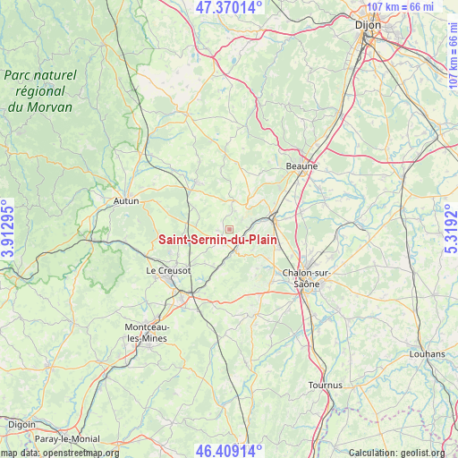
Saint-Sernin-du-Plain GPS coordinates[2]
46° 53' 30.444" North, 4° 36' 57.852" East
| Map corner | latitude | longitude |
|---|---|---|
| Upper-left | 47.37014°, | 3.91295° |
| Center: | 46.89179°, | 4.61607° |
| Lower-right: | 46.40914°, | 5.3192° |
| Map W x H: | 106.9×106.9 km | = 66.4×66.4mi |
| max Lat: | 51.07786° ⇑56.3% North |
| Saint-Sernin-du-Plain: | 46.89179° |
| min Lat: | ⇓43.7% South 41.3874° |
| min Long | Saint-Sernin-du | max Long |
| -5.08615° | 4.61607° | 9.52242° |
| W 72.9%⇐ | ⇒27.1% E |
Elevation
Elevation of Saint-Sernin-du-Plain is 386 m = 1266 ft, and this is 192.3 m = 631 ft above average elevation for this country.
| Max E: |
2333 m = 7654 ft | 12.1% |
| Saint-Sernin-du-Plain | 386 m 1266 ft | |
| Avg. | 193.7 m = 635 ft | |
Min E: |
-1 m = -3 ft | 87.9% |
See also: France elevation on elevation.city.
Geographical zone
Saint-Sernin-du-Plain is located in North temperate zone (between Tropic of Cancer and the Arctic Circle). Distance of this North polar circle is 2187.3 km =1359.1 mi to North.| Distance of | km | miles | from Saint-Sernin-du-Plain |
|---|---|---|---|
| North Pole | 4793.2 | 2978.4 | to North |
| Arctic Circle | 2187.3 | 1359.1 | to North |
| Tropic Cancer | 2608 | 1620.5 | to South |
| Equator | 5213.9 | 3239.8 | to South |


Nearby cities:
15 places around Saint-Sernin-du-Plain: (largest is in red/bold)
• Chagny
10.5 km =6.5 mi,  79°
79°
• Chaudenay
13.2 km =8.2 mi, 77°
• Corpeau
11.1 km =6.9 mi,  68°
68°
• Couches
4.7 km =2.9 mi,  233°
233°
• Fontaines
12.7 km =7.9 mi,  112°
112°
• Le Breuil
14.6 km =9.1 mi, 229°
• Mellecey
12.4 km =7.7 mi,  136°
136°
• Mercurey
9.6 km =6 mi,  126°
126°
• Nolay
6.8 km =4.2 mi,  11°
11°
• Rully
9.8 km =6.1 mi,  100°
100°
• Saint-Firmin
13.2 km =8.2 mi,  238°
238°
• Saint-Léger-sur-Dheune
5.4 km =3.4 mi,  163°
163°
• Saint-Pierre-de-Varennes
10.5 km =6.5 mi, 238°
• Santenay
6.6 km =4.1 mi, 69°
• Épinac
12.7 km =7.9 mi,  323°
323°
Sources, notices
• [Note1] Compared only with cities in France existing in our database
• [Src1] Map data: © OpenStreetMap contributors (CC-BY-SA)
• [Src2] Other city data from geonames.org with taken over terms of usage.
• [Src3] Geographical zone / Annual Mean Temperature by Robert A. Rohde @ Wikipedia
