Swanage geodata
Swanage (England) is a populated place; located in United Kingdom in Europe/London (GMT+1) time zone. With population of 10,454 people, there are 1015 cities with bigger population in this country. Compared to other cities in United Kingdom, 97.4% of cities are located further ↑North; 53.9% of cities are located further →East and 99% of cities have higher elevation than Swanage. Note1
Administrative division(s):
- Level 1: England
- Level 2: Dorset
- Level 3: Purbeck District
- Level 4: Swanage


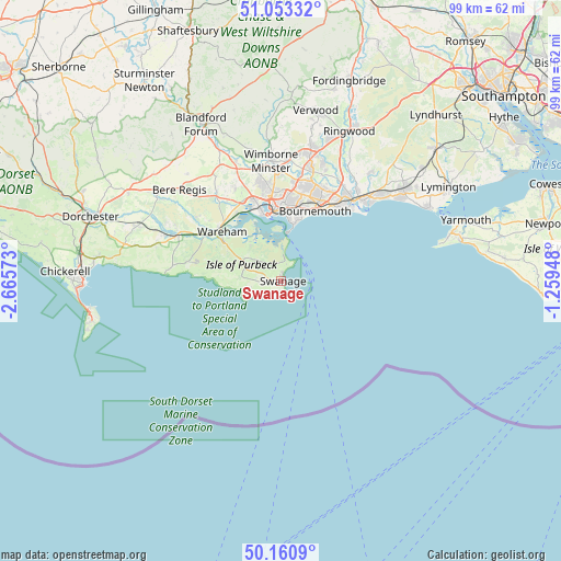
Swanage GPS coordinates[2]
50° 36' 33.228" North, 1° 57' 45.36" West
| Map corner | latitude | longitude |
|---|---|---|
| Upper-left | 51.05332°, | -2.66573° |
| Center: | 50.60923°, | -1.9626° |
| Lower-right: | 50.1609°, | -1.25948° |
| Map W x H: | 99.2×99.2 km | = 61.6×61.6mi |
| max Lat: | 60.39635° ⇑97.4% North |
| Swanage: | 50.60923° |
| min Lat: | ⇓2.6% South 34.60088° |
| min Long | Swanage | max Long |
| -7.64133° | -1.9626° | 32.95536° |
| W 46.1%⇐ | ⇒53.9% E |
Elevation
Elevation of Swanage is 4 m = 13 ft, and this is 68.9 m = 226 ft below average elevation for this country.
| Max E: |
515 m = 1690 ft | 99% |
| Avg. | 72.9 m = 239 ft | |
| Swanage | 4 m = 13 ft | |
Min E: |
-30 m = -98 ft | 1% |
See also: United Kingdom elevation on elevation.city.
Geographical zone
Swanage is located in North temperate zone (between Tropic of Cancer and the Arctic Circle). Distance of this North polar circle is 1774 km =1102.3 mi to North.| Distance of | km | miles | from Swanage |
|---|---|---|---|
| North Pole | 4379.8 | 2721.5 | to North |
| Arctic Circle | 1774 | 1102.3 | to North |
| Tropic Cancer | 3021.3 | 1877.3 | to South |
| Equator | 5627.2 | 3496.6 | to South |


Nearby cities:
15 places around Swanage: (largest is in red/bold)
• Bere Regis
24 km =14.9 mi,  312°
312°
• Bournemouth
13.7 km =8.5 mi,  25°
25°
• Bovington Camp
21.6 km =13.4 mi,  297°
297°
• Broadstone
16.6 km =10.3 mi,  352°
352°
• Canford Heath
15.8 km =9.8 mi,  358°
358°
• Christchurch
19 km =11.8 mi,  42°
42°
• Corfe Castle
7.4 km =4.6 mi, 296°
• Ferndown
22.5 km =14 mi,  11°
11°
• Lytchett Matravers
18.5 km =11.5 mi,  333°
333°
• Parkstone
13.5 km =8.4 mi, 5°
• Poole
11.8 km =7.3 mi, 352°
• Sturminster Marshall
22.6 km =14 mi,  339°
339°
• Wareham
13.6 km =8.5 mi, 309°
• Wimborne Minster
19.4 km =12.1 mi, 355°
• Wool
19.7 km =12.2 mi,  293°
293°
Sources, notices
• [Note1] Compared only with cities in United Kingdom existing in our database
• [Src1] Map data: © OpenStreetMap contributors (CC-BY-SA)
• [Src2] Other city data from geonames.org with taken over terms of usage.
• [Src3] Geographical zone / Annual Mean Temperature by Robert A. Rohde @ Wikipedia
