Lagodekhi geodata
Lagodekhi (Kakheti) is a populated place; located in Georgia in Asia/Tbilisi (GMT+4) time zone. With population of 6,550 people, there are 47 cities with bigger population in this country. Compared to other cities in Georgia, 64.1% of cities are located further ↑North; 100% of cities are located further ←West and 54.7% of cities have higher elevation than Lagodekhi. Note1


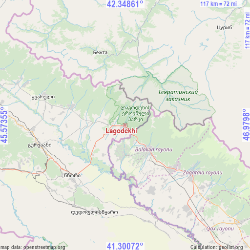
Lagodekhi GPS coordinates[2]
41° 49' 36.516" North, 46° 16' 36.012" East
| Map corner | latitude | longitude |
|---|---|---|
| Upper-left | 42.34861°, | 45.57355° |
| Center: | 41.82681°, | 46.27667° |
| Lower-right: | 41.30072°, | 46.9798° |
| Map W x H: | 116.5×116.5 km | = 72.4×72.4mi |
| max Lat: | 43.38111° ⇑64.1% North |
| Lagodekhi: | 41.82681° |
| min Lat: | ⇓35.9% South 41.21725° |
| min Long | Lagodekhi | max Long |
| 40.07944° | 46.27667° | 46.27667° |
| W 100%⇐ | ⇒0% E |
Elevation
Elevation of Lagodekhi is 469 m = 1539 ft, and this is 109.8 m = 360 ft below average elevation for this country.
| Max E: |
2223 m = 7293 ft | 54.7% |
| Avg. | 578.8 m = 1899 ft | |
| Lagodekhi | 469 m = 1539 ft | |
Min E: |
1 m = 3 ft | 45.3% |
See also: Georgia elevation on elevation.city.
Geographical zone
Lagodekhi is located in North temperate zone (between Tropic of Cancer and the Arctic Circle). Distance of this Northern Tropic circle is 2044.8 km =1270.6 mi to South.| Distance of | km | miles | from Lagodekhi |
|---|---|---|---|
| North Pole | 5356.4 | 3328.3 | to North |
| Arctic Circle | 2750.5 | 1709.1 | to North |
| Tropic Cancer | 2044.8 | 1270.6 | to South |
| Equator | 4650.7 | 2889.8 | to South |


Nearby cities:
15 places around Lagodekhi: (largest is in red/bold)
• Akhmet’a
91.3 km =56.7 mi,  284°
284°
• Bagdadi
20.2 km =12.6 mi,  266°
266°
• Didi Lilo
109.2 km =67.9 mi,  264°
264°
• Gardabani
106.5 km =66.2 mi,  247°
247°
• Gurjaani
40.5 km =25.2 mi, 256°
• Qvareli
40.6 km =25.2 mi,  290°
290°
• Rust’avi
110.9 km =68.9 mi, 253°
• Sagarejo
79 km =49.1 mi, 262°
• Sighnaghi
37.3 km =23.2 mi,  232°
232°
• Tbilisi
120.6 km =74.9 mi, 262°
• Telavi
67.3 km =41.8 mi, 278°
• Tsinandali
58.9 km =36.6 mi, 277°
• Tsnori
34.3 km =21.3 mi, 228°
• T’ianet’i
113 km =70.2 mi, 286°
• Zahesi
126.2 km =78.4 mi, 269°
Sources, notices
• [Note1] Compared only with cities in Georgia existing in our database
• [Src1] Map data: © OpenStreetMap contributors (CC-BY-SA)
• [Src2] Other city data from geonames.org with taken over terms of usage.
• [Src3] Geographical zone / Annual Mean Temperature by Robert A. Rohde @ Wikipedia
