Gurjaani geodata
Gurjaani (Kakheti) is a populated place; located in Georgia in Asia/Tbilisi (GMT+4) time zone. With population of 9,466 people, there are 36 cities with bigger population in this country. Compared to other cities in Georgia, 70.1% of cities are located further ↑North; 95.7% of cities are located further ←West and 57.3% of cities have higher elevation than Gurjaani. Note1


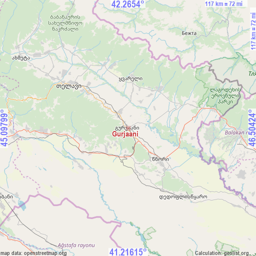
Gurjaani GPS coordinates[2]
41° 44' 34.512" North, 45° 48' 3.996" East
| Map corner | latitude | longitude |
|---|---|---|
| Upper-left | 42.2654°, | 45.09799° |
| Center: | 41.74292°, | 45.80111° |
| Lower-right: | 41.21615°, | 46.50424° |
| Map W x H: | 116.7×116.7 km | = 72.5×72.5mi |
| max Lat: | 43.38111° ⇑70.1% North |
| Gurjaani: | 41.74292° |
| min Lat: | ⇓29.9% South 41.21725° |
| min Long | Gurjaani | max Long |
| 40.07944° | 45.80111° | 46.27667° |
| W 95.7%⇐ | ⇒4.3% E |
Elevation
Elevation of Gurjaani is 400 m = 1312 ft, and this is 178.8 m = 587 ft below average elevation for this country.
| Max E: |
2223 m = 7293 ft | 57.3% |
| Avg. | 578.8 m = 1899 ft | |
| Gurjaani | 400 m = 1312 ft | |
Min E: |
1 m = 3 ft | 42.7% |
See also: Georgia elevation on elevation.city.
Geographical zone
Gurjaani is located in North temperate zone (between Tropic of Cancer and the Arctic Circle). Distance of this Northern Tropic circle is 2035.5 km =1264.8 mi to South.| Distance of | km | miles | from Gurjaani |
|---|---|---|---|
| North Pole | 5365.7 | 3334.1 | to North |
| Arctic Circle | 2759.8 | 1714.9 | to North |
| Tropic Cancer | 2035.5 | 1264.8 | to South |
| Equator | 4641.4 | 2884 | to South |


Nearby cities:
15 places around Gurjaani: (largest is in red/bold)
• Akhmet’a
58.7 km =36.5 mi,  303°
303°
• Bagdadi
20.9 km =13 mi,  66°
66°
• Didi Lilo
69.4 km =43.1 mi,  269°
269°
• Gardabani
66.7 km =41.4 mi,  241°
241°
• Lagodekhi
40.5 km =25.2 mi,  76°
76°
• Qvareli
23.6 km =14.7 mi,  3°
3°
• Rust’avi
70.5 km =43.8 mi,  252°
252°
• Sagarejo
39 km =24.2 mi, 268°
• Sighnaghi
16.9 km =10.5 mi,  143°
143°
• Tbilisi
80.5 km =50 mi, 266°
• Telavi
33.5 km =20.8 mi,  305°
305°
• Tsinandali
25.3 km =15.7 mi, 311°
• Tsnori
19.5 km =12.1 mi,  134°
134°
• T’ianet’i
80.3 km =49.9 mi, 300°
• Zahesi
87.3 km =54.2 mi,  275°
275°
Sources, notices
• [Note1] Compared only with cities in Georgia existing in our database
• [Src1] Map data: © OpenStreetMap contributors (CC-BY-SA)
• [Src2] Other city data from geonames.org with taken over terms of usage.
• [Src3] Geographical zone / Annual Mean Temperature by Robert A. Rohde @ Wikipedia
