Akhaldaba geodata
Akhaldaba (Ajaria) is a populated place; located in Georgia in Asia/Tbilisi (GMT+4) time zone. With population of 3,640 people, there are 64 cities with bigger population in this country. Compared to other cities in Georgia, 80.3% of cities are located further ↑North; 70.1% of cities are located further →East and 67.5% of cities have lower elevation than Akhaldaba. Note1


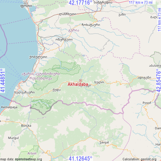
Akhaldaba GPS coordinates[2]
41° 39' 14.22" North, 42° 9' 5.868" East
| Map corner | latitude | longitude |
|---|---|---|
| Upper-left | 42.17716°, | 41.44851° |
| Center: | 41.65395°, | 42.15163° |
| Lower-right: | 41.12645°, | 42.85476° |
| Map W x H: | 116.8×116.8 km | = 72.6×72.6mi |
| max Lat: | 43.38111° ⇑80.3% North |
| Akhaldaba: | 41.65395° |
| min Lat: | ⇓19.7% South 41.21725° |
| min Long | Akhaldaba | max Long |
| 40.07944° | 42.15163° | 46.27667° |
| W 29.9%⇐ | ⇒70.1% E |
Elevation
Elevation of Akhaldaba is 748 m = 2454 ft, and this is 169.2 m = 555 ft above average elevation for this country.
| Max E: |
2223 m = 7293 ft | 32.5% |
| Akhaldaba | 748 m 2454 ft | |
| Avg. | 578.8 m = 1899 ft | |
Min E: |
1 m = 3 ft | 67.5% |
See also: Georgia elevation on elevation.city.
Geographical zone
Akhaldaba is located in North temperate zone (between Tropic of Cancer and the Arctic Circle). Distance of this Northern Tropic circle is 2025.6 km =1258.6 mi to South.| Distance of | km | miles | from Akhaldaba |
|---|---|---|---|
| North Pole | 5375.6 | 3340.2 | to North |
| Arctic Circle | 2769.7 | 1721 | to North |
| Tropic Cancer | 2025.6 | 1258.6 | to South |
| Equator | 4631.5 | 2877.9 | to South |


Nearby cities:
15 places around Akhaldaba: (largest is in red/bold)
• Adigeni
45.5 km =28.3 mi,  86°
86°
• Batumi
43 km =26.7 mi,  268°
268°
• Chakvi
35.7 km =22.2 mi,  282°
282°
• Dioknisi
20.1 km =12.5 mi,  97°
97°
• Keda
18.5 km =11.5 mi,  251°
251°
• Khelvachauri
40.8 km =25.4 mi,  259°
259°
• Khulo
12.7 km =7.9 mi, 95°
• Kobuleti
36.1 km =22.4 mi,  301°
301°
• Makhinjauri
38.1 km =23.7 mi, 273°
• Naruja
32.5 km =20.2 mi,  329°
329°
• Ochkhamuri
33.7 km =20.9 mi,  312°
312°
• Ozurgeti
32.4 km =20.1 mi,  338°
338°
• Shuakhevi
4.2 km =2.6 mi,  129°
129°
• Tsikhisdziri
35.2 km =21.9 mi,  290°
290°
• Urek’i
49 km =30.4 mi,  320°
320°
Sources, notices
• [Note1] Compared only with cities in Georgia existing in our database
• [Src1] Map data: © OpenStreetMap contributors (CC-BY-SA)
• [Src2] Other city data from geonames.org with taken over terms of usage.
• [Src3] Geographical zone / Annual Mean Temperature by Robert A. Rohde @ Wikipedia
