Shuakhevi geodata
Shuakhevi (Ajaria) is a seat of a second-order administrative division; located in Georgia in Asia/Tbilisi (GMT+4) time zone. With population of 380 people, there are 110 cities with bigger population in this country. Compared to other cities in Georgia, 83.8% of cities are located further ↑North; 69.2% of cities are located further →East and 55.6% of cities have lower elevation than Shuakhevi. Note1


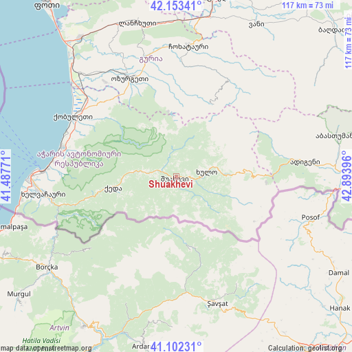
Shuakhevi GPS coordinates[2]
41° 37' 48" North, 42° 11' 26.988" East
| Map corner | latitude | longitude |
|---|---|---|
| Upper-left | 42.15341°, | 41.48771° |
| Center: | 41.63°, | 42.19083° |
| Lower-right: | 41.10231°, | 42.89396° |
| Map W x H: | 116.9×116.9 km | = 72.6×72.6mi |
| max Lat: | 43.38111° ⇑83.8% North |
| Shuakhevi: | 41.63° |
| min Lat: | ⇓16.2% South 41.21725° |
| min Long | Shuakhevi | max Long |
| 40.07944° | 42.19083° | 46.27667° |
| W 30.8%⇐ | ⇒69.2% E |
Elevation
Elevation of Shuakhevi is 572 m = 1877 ft, and this is 6.8 m = 22 ft below average elevation for this country.
| Max E: |
2223 m = 7293 ft | 44.4% |
| Avg. | 578.8 m = 1899 ft | |
| Shuakhevi | 572 m = 1877 ft | |
Min E: |
1 m = 3 ft | 55.6% |
See also: Georgia elevation on elevation.city.
Geographical zone
Shuakhevi is located in North temperate zone (between Tropic of Cancer and the Arctic Circle). Distance of this Northern Tropic circle is 2022.9 km =1257 mi to South.| Distance of | km | miles | from Shuakhevi |
|---|---|---|---|
| North Pole | 5378.2 | 3341.9 | to North |
| Arctic Circle | 2772.4 | 1722.7 | to North |
| Tropic Cancer | 2022.9 | 1257 | to South |
| Equator | 4628.8 | 2876.2 | to South |


Nearby cities:
15 places around Shuakhevi: (largest is in red/bold)
• Adigeni
42.6 km =26.5 mi,  82°
82°
• Akhaldaba
4.2 km =2.6 mi,  309°
309°
• Batumi
46.3 km =28.8 mi,  271°
271°
• Chakvi
39.5 km =24.5 mi,  285°
285°
• Dioknisi
16.7 km =10.4 mi,  90°
90°
• Keda
21.1 km =13.1 mi,  261°
261°
• Khelvachauri
43.7 km =27.2 mi, 263°
• Khulo
9.5 km =5.9 mi, 80°
• Kobuleti
40.2 km =25 mi,  301°
301°
• Lanchkhuti
52.8 km =32.8 mi,  345°
345°
• Makhinjauri
41.6 km =25.8 mi,  276°
276°
• Naruja
36.5 km =22.7 mi,  327°
327°
• Ochkhamuri
37.9 km =23.5 mi, 312°
• Ozurgeti
36.1 km =22.4 mi,  335°
335°
• Tsikhisdziri
39.2 km =24.4 mi, 292°
Sources, notices
• [Note1] Compared only with cities in Georgia existing in our database
• [Src1] Map data: © OpenStreetMap contributors (CC-BY-SA)
• [Src2] Other city data from geonames.org with taken over terms of usage.
• [Src3] Geographical zone / Annual Mean Temperature by Robert A. Rohde @ Wikipedia
