Kobuleti geodata
Kobuleti (Ajaria) is a seat of a second-order administrative division; located in Georgia in Asia/Tbilisi (GMT+4) time zone. With population of 18,600 people, there are 17 cities with bigger population in this country. Compared to other cities in Georgia, 65.8% of cities are located further ↑North; 80.3% of cities are located further →East and 98.3% of cities have higher elevation than Kobuleti. Note1


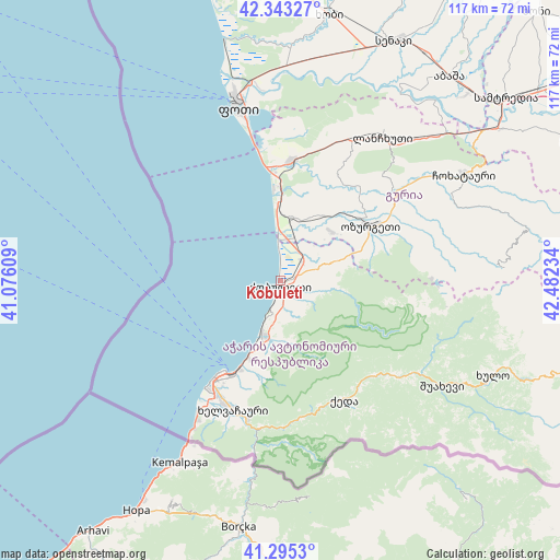
Kobuleti GPS coordinates[2]
41° 49' 17.148" North, 41° 46' 45.156" East
| Map corner | latitude | longitude |
|---|---|---|
| Upper-left | 42.34327°, | 41.07609° |
| Center: | 41.82143°, | 41.77921° |
| Lower-right: | 41.2953°, | 42.48234° |
| Map W x H: | 116.5×116.5 km | = 72.4×72.4mi |
| max Lat: | 43.38111° ⇑65.8% North |
| Kobuleti: | 41.82143° |
| min Lat: | ⇓34.2% South 41.21725° |
| min Long | Kobuleti | max Long |
| 40.07944° | 41.77921° | 46.27667° |
| W 19.7%⇐ | ⇒80.3% E |
Elevation
Elevation of Kobuleti is 3 m = 10 ft, and this is 575.8 m = 1889 ft below average elevation for this country.
| Max E: |
2223 m = 7293 ft | 98.3% |
| Avg. | 578.8 m = 1899 ft | |
| Kobuleti | 3 m = 10 ft | |
Min E: |
1 m = 3 ft | 1.7% |
See also: Georgia elevation on elevation.city.
Geographical zone
Kobuleti is located in North temperate zone (between Tropic of Cancer and the Arctic Circle). Distance of this Northern Tropic circle is 2044.2 km =1270.2 mi to South.| Distance of | km | miles | from Kobuleti |
|---|---|---|---|
| North Pole | 5357 | 3328.7 | to North |
| Arctic Circle | 2751.1 | 1709.5 | to North |
| Tropic Cancer | 2044.2 | 1270.2 | to South |
| Equator | 4650.1 | 2889.4 | to South |


Nearby cities:
15 places around Kobuleti: (largest is in red/bold)
• Akhaldaba
36.1 km =22.4 mi,  121°
121°
• Batumi
23.3 km =14.5 mi,  211°
211°
• Chakvi
11.4 km =7.1 mi,  199°
199°
• Keda
27.9 km =17.3 mi,  151°
151°
• Khelvachauri
27.8 km =17.3 mi, 199°
• Khulo
47.8 km =29.7 mi,  114°
114°
• Lanchkhuti
36.5 km =22.7 mi,  35°
35°
• Makhinjauri
17.9 km =11.1 mi, 203°
• Naruja
17.3 km =10.7 mi,  56°
56°
• Ochkhamuri
7.5 km =4.7 mi, 55°
• Ozurgeti
22.1 km =13.7 mi, 58°
• P’ot’i
37.2 km =23.1 mi,  346°
346°
• Shuakhevi
40.2 km =25 mi, 121°
• Tsikhisdziri
6.4 km =4 mi, 198°
• Urek’i
19.4 km =12.1 mi,  359°
359°
Sources, notices
• [Note1] Compared only with cities in Georgia existing in our database
• [Src1] Map data: © OpenStreetMap contributors (CC-BY-SA)
• [Src2] Other city data from geonames.org with taken over terms of usage.
• [Src3] Geographical zone / Annual Mean Temperature by Robert A. Rohde @ Wikipedia
