Naruja geodata
Naruja (Guria) is a populated place; located in Georgia in Asia/Tbilisi (GMT+4) time zone. With population of 3,065 people, there are 70 cities with bigger population in this country. Compared to other cities in Georgia, 59% of cities are located further ↑North; 76.1% of cities are located further →East and 69.2% of cities have higher elevation than Naruja. Note1


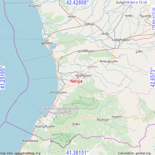
Naruja GPS coordinates[2]
41° 54' 24.984" North, 41° 57' 15.012" East
| Map corner | latitude | longitude |
|---|---|---|
| Upper-left | 42.42808°, | 41.25105° |
| Center: | 41.90694°, | 41.95417° |
| Lower-right: | 41.38151°, | 42.6573° |
| Map W x H: | 116.4×116.4 km | = 72.3×72.3mi |
| max Lat: | 43.38111° ⇑59% North |
| Naruja: | 41.90694° |
| min Lat: | ⇓41% South 41.21725° |
| min Long | Naruja | max Long |
| 40.07944° | 41.95417° | 46.27667° |
| W 23.9%⇐ | ⇒76.1% E |
Elevation
Elevation of Naruja is 144 m = 472 ft, and this is 434.8 m = 1427 ft below average elevation for this country.
| Max E: |
2223 m = 7293 ft | 69.2% |
| Avg. | 578.8 m = 1899 ft | |
| Naruja | 144 m = 472 ft | |
Min E: |
1 m = 3 ft | 30.8% |
See also: Georgia elevation on elevation.city.
Geographical zone
Naruja is located in North temperate zone (between Tropic of Cancer and the Arctic Circle). Distance of this Northern Tropic circle is 2053.7 km =1276.1 mi to South.| Distance of | km | miles | from Naruja |
|---|---|---|---|
| North Pole | 5347.4 | 3322.7 | to North |
| Arctic Circle | 2741.6 | 1703.6 | to North |
| Tropic Cancer | 2053.7 | 1276.1 | to South |
| Equator | 4659.6 | 2895.3 | to South |


Nearby cities:
15 places around Naruja: (largest is in red/bold)
• Abasha
40.2 km =25 mi,  33°
33°
• Akhaldaba
32.5 km =20.2 mi,  149°
149°
• Batumi
39.6 km =24.6 mi,  222°
222°
• Chakvi
27.3 km =17 mi, 222°
• Keda
34 km =21.1 mi,  181°
181°
• Khulo
41.2 km =25.6 mi,  135°
135°
• Kobuleti
17.3 km =10.7 mi,  236°
236°
• Lanchkhuti
21.4 km =13.3 mi,  17°
17°
• Makhinjauri
33.7 km =20.9 mi, 219°
• Ochkhamuri
9.9 km =6.2 mi, 237°
• Ozurgeti
4.8 km =3 mi,  65°
65°
• P’ot’i
35.4 km =22 mi,  318°
318°
• Shuakhevi
36.5 km =22.7 mi, 147°
• Tsikhisdziri
22.7 km =14.1 mi,  226°
226°
• Urek’i
17.5 km =10.9 mi,  304°
304°
Sources, notices
• [Note1] Compared only with cities in Georgia existing in our database
• [Src1] Map data: © OpenStreetMap contributors (CC-BY-SA)
• [Src2] Other city data from geonames.org with taken over terms of usage.
• [Src3] Geographical zone / Annual Mean Temperature by Robert A. Rohde @ Wikipedia
