Tríkala geodata
Tríkala (Thessaly) is a seat of a second-order administrative division; located in Greece in Europe/Athens (GMT+3) time zone. With population of 61,653 people, there are 26 cities with bigger population in this country. Compared to other cities in Greece, 58% of cities are located further ↓South; 77.1% of cities are located further →East and 59.3% of cities have lower elevation than Tríkala. Note1


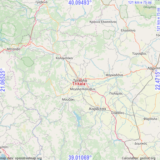
Tríkala GPS coordinates[2]
39° 33' 17.748" North, 21° 46' 6.132" East
| Map corner | latitude | longitude |
|---|---|---|
| Upper-left | 40.09493°, | 21.06525° |
| Center: | 39.55493°, | 21.76837° |
| Lower-right: | 39.01069°, | 22.4715° |
| Map W x H: | 120.6×120.6 km | = 74.9×74.9mi |
| max Lat: | 41.72048° ⇑42% North |
| Tríkala: | 39.55493° |
| min Lat: | ⇓58% South 34.8346° |
| min Long | Tríkala | max Long |
| 19.40494° | 21.76837° | 29.59361° |
| W 22.9%⇐ | ⇒77.1% E |
Elevation
Elevation of Tríkala is 114 m = 374 ft, and this is 54.9 m = 180 ft below average elevation for this country.
| Max E: |
1439 m = 4721 ft | 40.7% |
| Avg. | 168.9 m = 554 ft | |
| Tríkala | 114 m = 374 ft | |
Min E: |
0 m = 0 ft | 59.3% |
See also: Tríkala elevation on elevation.city.
Geographical zone
Tríkala is located in North temperate zone (between Tropic of Cancer and the Arctic Circle). Distance of this Northern Tropic circle is 1792.2 km =1113.6 mi to South.| Distance of | km | miles | from Tríkala |
|---|---|---|---|
| North Pole | 5609 | 3485.3 | to North |
| Arctic Circle | 3003.1 | 1866 | to North |
| Tropic Cancer | 1792.2 | 1113.6 | to South |
| Equator | 4398.1 | 2732.9 | to South |


Nearby cities:
15 places around Tríkala: (largest is in red/bold)
• Ardáni
8.7 km =5.4 mi,  10°
10°
• Droseró
5.5 km =3.4 mi,  204°
204°
• Flamoúli
3.2 km =2 mi,  183°
183°
• Kefalóvryso
7.1 km =4.4 mi,  294°
294°
• Megalochóri
6.3 km =3.9 mi,  85°
85°
• Megála Kalývia
6.7 km =4.2 mi,  165°
165°
• Mouriá
8.5 km =5.3 mi,  210°
210°
• Méga Kefalóvryso
5.1 km =3.2 mi,  318°
318°
• Palaiópyrgos
7.3 km =4.5 mi,  35°
35°
• Patouliá
8.5 km =5.3 mi,  105°
105°
• Pigí
7.6 km =4.7 mi,  229°
229°
• Pyrgetós
1.7 km =1.1 mi,  261°
261°
• Rizarió
3.3 km =2.1 mi,  122°
122°
• Ráxa
6.5 km =4 mi,  343°
343°
• Zileftí
5.6 km =3.5 mi,  51°
51°
Sources, notices
• [Note1] Compared only with cities in Greece existing in our database
• [Src1] Map data: © OpenStreetMap contributors (CC-BY-SA)
• [Src2] Other city data from geonames.org with taken over terms of usage.
• [Src3] Geographical zone / Annual Mean Temperature by Robert A. Rohde @ Wikipedia
