Flamoúli geodata
Flamoúli (Thessaly) is a populated place; located in Greece in Europe/Athens (GMT+3) time zone. With population of 560 people, there are 1679 cities with bigger population in this country. Compared to other cities in Greece, 57.2% of cities are located further ↓South; 77.1% of cities are located further →East and 57.7% of cities have lower elevation than Flamoúli. Note1


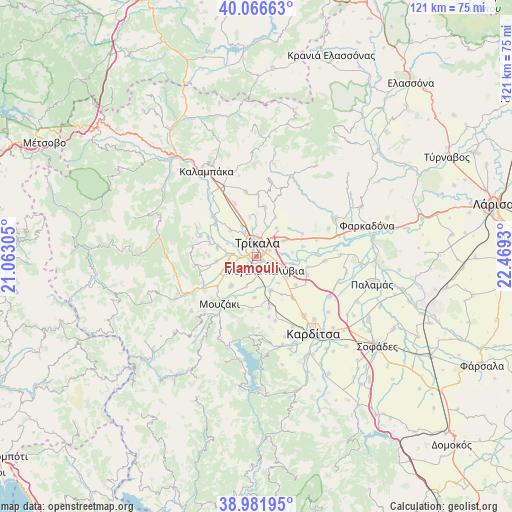
Flamoúli GPS coordinates[2]
39° 31' 35.076" North, 21° 45' 58.212" East
| Map corner | latitude | longitude |
|---|---|---|
| Upper-left | 40.06663°, | 21.06305° |
| Center: | 39.52641°, | 21.76617° |
| Lower-right: | 38.98195°, | 22.4693° |
| Map W x H: | 120.6×120.6 km | = 74.9×74.9mi |
| max Lat: | 41.72048° ⇑42.8% North |
| Flamoúli: | 39.52641° |
| min Lat: | ⇓57.2% South 34.8346° |
| min Long | Flamoúli | max Long |
| 19.40494° | 21.76617° | 29.59361° |
| W 22.9%⇐ | ⇒77.1% E |
Elevation
Elevation of Flamoúli is 108 m = 354 ft, and this is 60.9 m = 200 ft below average elevation for this country.
| Max E: |
1439 m = 4721 ft | 42.3% |
| Avg. | 168.9 m = 554 ft | |
| Flamoúli | 108 m = 354 ft | |
Min E: |
0 m = 0 ft | 57.7% |
See also: Greece elevation on elevation.city.
Geographical zone
Flamoúli is located in North temperate zone (between Tropic of Cancer and the Arctic Circle). Distance of this Northern Tropic circle is 1789 km =1111.6 mi to South.| Distance of | km | miles | from Flamoúli |
|---|---|---|---|
| North Pole | 5612.1 | 3487.2 | to North |
| Arctic Circle | 3006.2 | 1868 | to North |
| Tropic Cancer | 1789 | 1111.6 | to South |
| Equator | 4394.9 | 2730.9 | to South |


Nearby cities:
15 places around Flamoúli: (largest is in red/bold)
• Agnanteró
8.3 km =5.2 mi,  122°
122°
• Droseró
2.8 km =1.7 mi,  229°
229°
• Lazarína
7.5 km =4.7 mi,  198°
198°
• Lygariá
7.9 km =4.9 mi,  243°
243°
• Megalochóri
7.5 km =4.7 mi,  60°
60°
• Megála Kalývia
3.8 km =2.4 mi,  150°
150°
• Mouriá
5.9 km =3.7 mi, 225°
• Méga Kefalóvryso
7.7 km =4.8 mi,  335°
335°
• Palaiochóri
8.1 km =5 mi,  141°
141°
• Patouliá
8.5 km =5.3 mi,  83°
83°
• Pigí
5.9 km =3.7 mi,  252°
252°
• Pyrgetós
3.3 km =2.1 mi,  332°
332°
• Rizarió
3.3 km =2.1 mi, 64°
• Tríkala
3.2 km =2 mi,  3°
3°
• Zileftí
8.1 km =5 mi,  34°
34°
Sources, notices
• [Note1] Compared only with cities in Greece existing in our database
• [Src1] Map data: © OpenStreetMap contributors (CC-BY-SA)
• [Src2] Other city data from geonames.org with taken over terms of usage.
• [Src3] Geographical zone / Annual Mean Temperature by Robert A. Rohde @ Wikipedia
